The Tropical Watching Begins

The are patterns to the season. Water temperatures and upper winds favor different places for formation at different times of the season. Right now the Atlantic is open for business!

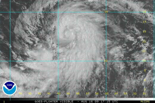
I’ve been watching Colin. He’s the blob of clouds in the satellite image just above this text . Not very impressive looking.

He was a low then a tropical storm, then a remnant low, now a tropical storm again. Way out to sea Colin has posed a threat to no one.

Later storms will transfix me. Not Colin.

I watch storms differently than amateurs. I’m a charts, graphs and maps guy. Much of what I get is raw data. The rest flows from the Hurricane Center.

The National Hurricane Center is run like a university research project. There are forecasts for sure, but it doesn’t end there. Every system is sliced and diced in the open. The Hurricane Center issues written forecast discussions every six hours.

Because of decades old protocols everything is UPPER CASE. Here’s a short snippet (and a link to the full text of the most current discussion).

SOUTHWESTERLY VERTICAL SHEAR OF 20-25 KT CONTINUES TO HINDER SIGNIFICANT INTENSIFICATION OF COLIN…AND THESE UNFAVORABLE CONDITIONS ARE EXPECTED TO CONTINUE THROUGH THE NEXT 24 HOURS. HOWEVER…FROM 36 TO 48 HOURS…ALL OF THE GLOBAL MODELS ARE FORECASTING THE VERTICAL SHEAR TO WEAKEN SIGNIFICANTLY AS COLIN PASSES BETWEEN TWO UPPER-LEVEL LOWS AND MOVES UNDER A SMALL RIDGE…WHICH PROVIDES A BRIEF WINDOW OF OPPORTUNITY FOR COLIN TO STRENGTHEN. THE SHIPS AND LGEM MODELS BRING COLIN TO NEAR 60 KT BY 48 HOURS…WHEN THE CYCLONE IS NEAR BERMUDA…AND THIS TREND WAS FOLLOWED FOR THIS ADVISORY PACKAGE.

Nodding off?

Even after a storm dissipates lengthy papers are published. Here’s 43 pages on Katrina!

NHC does a pretty good job mostly–not always. I’m not saying anyone does better, just NHC isn’t always right. That can apply even when a storm is poised for landfall! It’s not like they’re not trying.

The science of forecasting hasn’t been perfected. More data would help. It still won’t totally solve the problem.

It’s easy to be thrown off because NHC issues definitive measurements that make it seem the storm has been measured with a microscope and calipers.

SUMMARY OF 200 AM AST…0600 UTC…INFORMATION
———————————————-
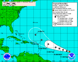
LOCATION…26.3N 67.1W
ABOUT 445 MI…715 KM SSW OF BERMUDA
MAXIMUM SUSTAINED WINDS…50 MPH…85 KM/HR
PRESENT MOVEMENT…NNW OR 335 DEGREES AT 14 MPH…22 KM/HR
MINIMUM CENTRAL PRESSURE…1007 MB…29.74 INCHES

Each of those numbers looks firm and exact. It’s really an estimate. The farther a storm is from shore the rougher those estimates are. Who can question them?

When Colin was first sighted over 2,600 miles from here there wasn’t much more than satellite observations to go by. Instrumentation off the coast of Africa is a little wanting. Everything was an educated guess–no more. It was too far away for the Hurricane Hunter airplanes to even consider.

A bad estimate has little downside when a storm is in an isolated corner of the ocean.

It sometimes seems like the Hurricane Center is cognizant of how their forecasts are used and smooths out the variability in storms. You don’t want people to let their guard down.

The slower a storm moves the more difficult it is to forecast. I’ve never seen the official forecast show a hurricane looping its own track. I’ve seen it happen enough times it no longer surprises me.

The are patterns to the season. Water temperatures and upper winds favor different places for formation at different times of the season. Right now the Atlantic is open for business!

Though the season began June 1 it’s about to hit its most active time peaking the second week in September. It’s seasonal the way the fall colors are predictably seasonal.

I’ll continue to watch Colin for the same reason a ballplayer takes BP in spring training. I need to get back into the rhythm. I need to practice using tools I haven’t used since last fall.

Not every storm will be Colin.

The Tropics Are Open For Business

After a non-existent early season the tropics are open for business. In a few short days we’ve seen Ana, Bill and now Claudette.

tropical storm bill sunday.jpg

My folks are on their way to Milwaukee tomorrow where my niece is expecting their first great-grandchild. Her first child too, but I’ll see it through their eyes right now.

In Florida where they live there is special preferred parking for great-grandparents.

OK, I made that up, but there might as well be! It’s the Florida condo equivalent of receiving the Congressional Medal of Honor.

Anyway they fly out tomorrow. I called them yesterday.

“Get the hurricane shades rolled down.”

I’m glad they’ll be out-of-town.

After a nonexistent early season the tropics are open for business. In a few short days we’ve seen Ana, Bill and now Claudette. Ana fizzled. Claudette will cause problems on the Gulf Coast, but probably as a tropical storm of minimal hurricane. Bill is the big worry.

I am actually more worried about Bill than Claudette even though Claudette will surely make landfall while the track of Bill is nowhere near as well defined.

ENVIRONMENTAL CONDITIONS APPEAR FAVORABLE FOR CONTINUED INTENSIFICATION DUE TO LIGHT SHEAR AND WARM WATERS. SSTS BEGIN TO RISE MORE SIGNIFICANTLY IN A COUPLE OF DAYS AND THE NHC INTENSITY FORECAST COULD BE CONSERVATIVE AFTER THAT TIME. ALL RELIABLE GUIDANCE SHOWS THIS SYSTEM EVENTUALLY BECOMING A MAJOR HURRICANE. – National Hurricane Center discussion

bill track sunday.gifI don’t disagree. And since this storm seems to be destined to turn parallel to the East Coast I worry–not just for my parents.

As storms get closer to land the ability to monitor them improves. Hurricane Hunter flights don’t go out into the mid-Atlantic. Buoys and remote sensors are limited in the middle of the ocean. Radar only covers a few hundred miles from shore.

This will not be my last entry on Bill.

Hurricane Wilma On My Mind

I so wanted to make a joke about Wilma and Fred Flintstone. The window of opportunity to look at this as a funny little storm came and went in an instant. Wilma has me worried.

At the moment, the best view is from satellite, though I suspect the Mexican radar at Cancun will start seeing the structure of the storm later today.

This is not a good scenario for my folks who live in Southern Palm Beach County, Florida. In fact, it’s just not good for anyone in South Florida – and I believe they know it.

For many in Florida the first hurricane was an adventure. That romantic outlook is long gone. Hurricanes are terrifying and you don’t need a direct hit to bring grief, trouble, inconvenience and cost.

I’ll bet my folks put the hurricane shutters down a little quicker this time.

I was up, chatting with my friend Bob last night when the first signs of major trouble came in. Bob has his PhD in meteo, so it’s no stretch to say he’s much geekier and meteorologically adept than I am. He was reading the raw recon data from the Hurricane Hunter plane. I seldom do that when a storm is so far from land.

He tipped me of to the report of the 3 nautical mile eye&#185. We were both amazed. Then he caught the pressure fall. That was even more stunning.

This is my analogy, so Bob can distance himself if it’s not 100% on the mark: The pressure had dropped so much that being at a point the eye passed (impossible in real life, but stay with me here) would have been the equivalent of sitting on the wing of a twin engine prop plane as it took of and climbed to about 5,000 feet. The wind you’d feel and pressure drop you’d experience were pretty similar.

First the good news. Wilma will not stay at 175 mph. I’ve gone over this before, but it bears repeating. There is a ‘sweet spot’ for hurricanes where they can achieve symmetry and near physical perfection. As soon as one little parameter goes out of balance, that symmetry breaks down and the storm loses strength.

That being said, going from 175 mph to, let’s say 130 mph, isn’t much comfort.

Oh – did I mention Wilma could head for New England? My gut tells me it’s wide and to the right, but too close to dismiss at the moment.

If… again, that’s if… it does come north and does affect New England, the storm’s structure and forward speed (along with hurricane wind speed) will need to be closely watched. The Great New England Hurricane of ’38 hit Fairfield County, Connecticut, but its greatest hurricane force winds were felt 100 miles or more east of the center!

I’ll be writing more about Wilma later today. In the meantime, the hurricane links on the right side of this page are ‘live’ and will get you to the latest hurricane info, no matter when you read this.

&#185 – It might have gotten smaller today. I saw a reference to a 2 nautical mile eye on Dr. Jeff Masters blog.

Another Day in Birmingham

I didn’t know what to expect. I’m in Birmingham, AL for the conference that concludes my Mississippi State University education.

I’ll go over this in more detail later, but much of what I’ve heard has been interesting. I’m not totally sure it wasn’t covered in my classes for the most part.

We heard from a local meteorologist, Air Force Reserve “Hurricane Hunter” meteorologist and one of the MSU professors today.

He was actually the surprise of the bunch. His case study on a severe weather outbreak in the Southern Plains was interesting to follow and predict (even though it’s already happened).

The meetings start early (for me) at 8:30 and continues to 7:00 PM or later. That’s a long day.

Each session ends with a tape swap. Everyone brought an aircheck of their work and we all watch together.

I brought a broadcast from Monday. It was an evening with thunderstorms passing through the state and a Severe Thunderstorm Watch for Northwest Connecticut.

It’s funny. I’m on TV every day, yet I’m spooked by the idea of my fellow students seeing my presentation.

I’ve dodged that bullet the last two afternoons, but tomorrow’s the last chance and I’m certain it will be shown.

Not that it will get me an easier audience, but I’m here with a bunch of mostly nice people. There are a few spectacular looking women.

Stay Safe… Except Me

Hurricane Alex has just left the East Coast. Within days it will be a memory, absorbed into the normal flow of extra-tropical weather. As hurricanes go, it was small and its impact to the Carolina’s will be discernible, but small.

Since Alex was never thought to be a huge storm, I didn’t get to cringe at the sight of TV reporters, and weather people, standing in the thick of it all – all the while telling others to stay inside where it’s safe.

I think this is right up there with tobacco companies telling me not to smoke. Where’s the credibility.

I know where this came from. Dan Rather got his TV chops covering a hurricane in Texas. It was because of that very gritty series of on-location reports that he was plucked from obscurity. Good for Dan.

The problem is, all the warnings we give on TV are correct. Hurricanes are dangerous storms. Being in the midst of an open area, adjacent to open water, with a hurricane coming on shore, is going to get someone killed.

I have watched live shots as reporters tilted off vertical, into the wind, in order to stand. In the background of those shots I’ve also seen debris and building materials turned into missiles. That they didn’t find a reporter is only luck.

In a larger sense, aren’t we sending the wrong signal to viewers? It’s a ‘do as I say’ mentality that will entice others into harm’s way.

You might be saying, “But Geoff, you’ve flown through the eye of two hurricanes. Isn’t that a little crazier and a lot more dangerous?”

Thanks. I’m glad I asked that.

Flying through a hurricane is totally different. The planes are specifically outfitted to withstand the buffeting they get. The planes are flown at an altitude where there is no solid debris to run into. And the well trained crews have the benefit of radar and other instrumentation to know where, and where not, to go.&#185

I also won’t criticize tornado chasers. As far as I can tell, no one has ever been hurt while chasing a tornado. These are compact systems with reasonably predictable paths. It is quite reasonable to watch a tornado safely from a distance, if you know what you’re doing.

Back when I did PM Magazine/Buffalo I used to joke around about the fact that you can’t get hurt if you’re in front of a camera and tape’s rolling. Of course that’s just not so. Unfortunately, it looks like a lot of the reporters in big storms feel just that way.

I hope this isn’t the year when something tragic happens. That time is coming. It’s not a question of if, but when.

&#185 – Hurricane Hunter planes never fly directly into the eye. They always turn into the wind and cut diagonally to the eye. This makes some of the terrible force near the center nothing more than a ferocious headwind.

Father’s Day

What a beautiful day. This was a day for shooting picture postcards or travelogues. The sky was a pure blue without a hint of gray. The clouds were scattered and puffy. The air was warm and crisp at the same time.

Oh – it’s Father’s Day.

I’m not sure why we’re being feted, but we are. After all, in the hierarchy of parents, I think moms have it tougher. However, I am not one to look a gift horse in the mouth.

Steffie had handmade a card for me. Even at age 17, when she’s part child – part adult, this effort on her part warms every part of me. It is a collage – an abstract from magazines. It is a style in which she has shown great talent. I envy her skills as an artist.

Helaine bought me a few gifts: a book on poker (Doyle Brunson’s “Super System,” considered the classic in its field), cuff links made from small pieces of a computer motherboard, and a trip in a balloon over Las Vegas.

A good daughter-in-law, she got my dad that too. He’ll be joining me as we fly in wicker!

I love to fly. Once, a long time ago, I even took lessons… though I quit before I soloed.

I have flown in nearly anything you can think of from an ultralight with two chainsaw engines for power, to a Piper Cub J-3 with fabric covered wings, to a C-5A big enough to hold a Greyhound bus. I’ve had a few minutes stick time in an F/A18 with the Blue Angels and in a military full motion simulator. I’ve also flown through 2 hurricanes in a C-130 Hurricane Hunter (not as scary as you might think). There have also been flights in a few helicopters, one blimp and some time in Houston walking through a Space Shuttle trainer.

My first balloon flight was in the 80’s during my PM Magazine/Buffalo days. The pilot was Einer Wheel (a name you don’t easily forget) and the balloon was festooned with ads for a local Western New York bank. Later, with the SciFi Channel crew, I flew in the Canadian Flag balloon during a mass ascension at the Kodak Albuquerque International Balloon Fiesta.

I’m looking forward to this balloon trip because it’s over Las Vegas (though probably not over the Strip), which will provide an immense panorama, and because it will be with my dad. This is the kind of thing he’d never do on his own and something he’ll really enjoy a lot.

This being Father’s Day, I went a little nuts and went off my diet. Helaine and Steffie took me to The Rusty Scupper for brunch. With today’s weather, and its location right on New Haven Harbor, it was the perfect spot.

Father’s Day ends at midnight. I’ll be dieting again tomorrow, trying to gain a cushion for our Vegas vacation. I was king for a day. It’s good to be king.