Twitter Is Holding My Attention

kevinrose Just walked into the bar with this dog (see earlier vid), holy hell, 5 girls came up in 2 mins. This dog is gold!

I’m still up in the air about Twitter. I like it, but I’m feeling unfulfilled. Maybe I don’t know how to use it correctly. It would work a whole lot better if “twits” updated in real time and the whole thing operated outside the browser.

Here are some random “twits” I enjoyed… and the raison d’être I come back.

Kevin Rose kevinrose Just walked into the bar with this dog (see earlier vid), holy hell, 5 girls came up in 2 mins. This dog is gold!

Harry McCracken harrymccracken Just felt it! (There was a small quake in Northern California last night – Geoff)

LanceUlanoff Curse you Brett Myers!

mattcutts Duncan Riley is auctioning his original Google Chrome comic book: http://bit.ly/ebaychrome .

mattizcoop Chilling with the boy, regretting the 5:55 AM flight out of MSP, bumming out that Heart put the kibosh on use of “Barracuda” for Sarahcuda.

anamariecox Forgotten Tweet from Google bash: asked vet GOP operative what he thought of the nite’s stagecraft and he said “my eyes are still bleeding.”

Brian Heater bheater @dancosta Microsoft is to the Future as McCain is to Change. Discuss

HowardKurtz So many media folks on this plane, hope the Repubs dont launch an elite-seeking missile.

Kirk Varner kirkv Anyone want to wager that these are the last political party conventions that ABC/CBS/NBC give up any primetime for?

Mr. TV Barn tvbarn Watching the Royals play a makeup game in an almost entirely empty Kauffman Stadium; you can even hear Jose Guillen grumbling in the dugout

geofffox Mixed emotions hoping winds/rain are heavy enough to justify my forecast, light enough not to injure. Always forecast with conscience.

The world summarized in 140 characters or less!

Weather News I Missed

At least 55 people have died and 2.5 million have been displaced as the river changed its course. Thousands more people are being evacuated to higher ground to escape the rising floodwaters.

kosi-river-nepal.jpg

I was just scouting around the web looking for as much on Hurricane Gustav as I could find. From the official Cuban government weather site I was directed to the World Meteorological Organization’s site. Usually there’s little of interest from the WMO–a top-heavy international bureaucracy with nearly no operational responsibility.

“On 18 August, after heavy monsoon rains, a dam on the Saptakoshi (Kosi) river in Nepal burst, leaving tens of thousands of people homeless and triggering flooding in the neighbouring Indian state of Bihar, where at least 55 people have died and 2.5 million have been displaced as the river changed its course. Thousands more people are being evacuated to higher ground to escape the rising floodwaters. Roads and railway tracks have been washed away and water and electricity supplies have been affected in many areas.”

That’s staggering. 2.5 million people displaced. I can’t imagine what it must be like there.

Why haven’t I heard or read about this? Are American’s really that isolated from the rest of the world? Am I that isolated?

Gustav’s Amazing Growth Spurt

The wind, nearly doubled in speed, has almost four times the power. The rule of thumb says it will destroy eight times as much as last night’s storm would.

The ability of a hurricane to rapidly increase in intensity never ceases to amaze me. Last night when I went to bed Gustav had a top sustained wind speed of 80 mph. Now, less that 12 hours later it’s 145 mph! The wind, nearly doubled in speed, has almost four times the power. The rule of thumb says it will destroy eight times as much as last night’s storm would.

This radar image is a snapshot in time. Part of the power of the Internet this is an image I never had access to–direct from the Cuban government’s weather bureau&#185. Gustav is about to attack the Isle of Youth (formerly the Isle of Pines) and its 100,000 residents.

I expect the storm to weaken as it passes over Western Cuba then strengthen again in the Gulf.

I’ve written about this before and discussed it often with my friend Bob. There is an internal balance necessary for a hurricane to get to 140 mph or more. That speed is almost impossible to maintain for any length of time. Gustav will see its intensity pulse up-and-down once it reestablishes itself in the Gulf. Hopefully, landfall will come as it is diminishing.

&#185 – It’s interesting that the Instituto de Meteoologia de la Republica de Cuba–part of a ‘people’s paradise,’ finds it necessary to add: “Copyright © 1997-2008. INSMET ® Todos los derechos reservados ” Am I surprised? Todo-lly.

Gustav And The New Orleans Quandary

The damage in New Orleans was hurricane related, but it wasn’t the damage you expect in a hurricane. On the Mississippi coast structures were blown apart. In New Orleans most buildings were intact until they were flooded.

As I type this, Gustav is somewhere near the Cayman Islands, picking up strength and heading toward the Gulf of Mexico. The Gulf is warm. Gustav will strengthen some more.

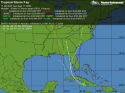
For the past few days the official Hurricane Center Track has pushed Gustav toward the Louisiana coast sometime late Monday/early Tuesday. The latest center of the track would bring landfall west of the Mississippi over a swampy, sparsely populated area near Vermillion Bay. That would put New Orleans on the stronger side of the storm, but possibly far enough away to escape the worst. Katrina struck on the opposite side of New Orleans–actually on the Mississippi coast. For Katrina, New Orleans was on the weak side!

Monday’s a long way off. The track will certainly shift somewhat by then.

There is a misconception most people have about Katrina. I’m writing tonight to put that part of the Katrina saga in perspective. The damage in New Orleans was hurricane related, but it wasn’t the damage you expect in a hurricane. On the Mississippi coast structures were blown apart. In New Orleans most buildings were intact until they were flooded.

I’m not saying there wasn’t damage before the water–there most certainly was. But New Orleans wasn’t flattened by a hurricane. It didn’t receive strong and sustained hurricane force winds. It was not the ‘worst case scenario’ storm New Orleans had feared.

I wrote this as Katrina began to pull away Monday evening.

Katrina Comes Ashore 08/29/05 9:21 PM

New Orleans wasn’t totally laid to waste. There has been plenty of damage, and once we get out of the ‘fog of war’ we’ll find plenty more. The coasts of Alabama and Mississippi really took the brunt of Hurricane Katrina. That was more than expected.

After the fact, I still agree with the decision to empty out New Orleans. Yes, some people will crawl out of the woodwork to say they rode it out and it wasn’t that bad. That’s not the point.

At this point the New Orleans hurricane damage from Katrina wasn’t that bad. The damage we all saw didn’t start until later Monday night long after the storm was over. It was as if the Katrina unfolded in slow motion.

Bad News For New Orleans, Out of Left Field 08/30/05 3:02 AM

Rick Sanchez was on the air, speaking by phone with someone from Tulane Hospital in New Orleans. The hospital’s spokesperson was talking about water – rising water.

The hospital had seen no real flooding while Hurricane Katrina passed by, but tonight, water had begun rushing in and it was rising at an alarming rate.

I could hear the fear in her voice as she described the water level rising an inch every five minutes. That’s a foot an hour. Already there was six feet of water outside the hospital. Soon, water would reach the level of their emergency generators on the second floor.

Sanchez was taken aback. I’m not sure he originally understood what she was saying. It was so unexpected – so out of context.

She said a levee keeping Lake Ponchartrain out of New Orleans had been breached. The cut in the levee was two blocks long and water was rushing in unimpeded. Even if there were pumps working, and she wasn’t sure there were, they wouldn’t be able to keep up with this deluge.

On CNN, Rick Sanchez kept asking questions, but it was obvious this woman wanted to get off the phone. Speaking to him wasn’t going to help her.

I heard terror in her voice.

The hospital had to get its patients out. Its patients were by and large critical. The only way to move them would be by helicopter and FEMA would be needed for that.

The other all news stations are in their usual reruns. I have no way of knowing if this is true. If it is, this is New Orleans’ worst fears are realized. Lake Ponchartrain could inundate the city.

Here’s my point. If Gustav gets strong (likely) and hits just west of New Orleans (possible) there will be a different type of damage in the Crescent City. New Orleans could just get blown over. Nothing FEMA or the Corps of Engineers has done would prevent this kind of destruction.

I’m not sure which scenario is worse–what happened in ’05 or what’s possible in a few days. They are not, unfortunately, mutually exclusive scenarios.

Gustav Now On My Radar

The route is totally different from Katrina’s, but the projected destination is eerily similar.

Three years ago today I was on the phone with Farrell’s mom Ruth, try to get her out of New Orleans. Here’s what I wrote that day. Now I’m worried about New Orleans again.

Gustav is south of Cuba, heading toward Jamaica and the Cayman Islands. The route is totally different from Katrina’s, but the projected destination is eerily similar.

Much of the controlling mechanism behind hurricanes is seasonably predictable. At different times in the hurricane season different areas are favored for development and track. It’s not a big surprise a potential hurricane is aiming at the mid-Gulf Coast on Katrina’s anniversary week.

Gustav will gain strength. It’s tough to think it will go anywhere but the Gulf. I’m scared it will plow into the Gulf Coast states. I hope I’m wrong. It’s a hope I have too often during the hurricane season.

Charley Meet Fay

I remember Charley blossomed very quickly before landfall.

fay forecast.gifTropical Storm Fay’s track is starting to resemble Hurricane Charley’s. Charley hit Florida’s west coast four years ago this past week. Certainly, Charley took a more southerly path getting there, avoiding Hispanola and the interaction Fay is having with Cuba’s landmass. From here on out the forecast tracks are very similar.

I remember Charley blossomed very quickly just before landfall.

Charley rapidly intensified, strengthening from a 110 mph (180 km/h) hurricane with a minimum central barometric pressure of 965 mbar (hPa; 28.50 inHg) to a 145 mph (230 km/h) hurricane with a pressure of 941 mbar (hPa; 27.49 inHg) in just 6 hours. The storm continued to strengthen as it turned more to the northeast, and made landfall near the island of Cayo Costa, Florida as a 150 mph (240 km/h) Category 4 hurricane at approximately 3:45 p.m. EDT (1945 UTC) on the 13th. An hour later, the hurricane struck Punta Gorda as a 145 mph (230 km/h) storm. However, the eye had shrunk before landfall, limiting the most powerful winds to an area of 6 nautical miles (11 km) of the center.

Fay will cross Cuba a weaker storm. Cuba is quite mountainous (ask Fidel), the hurricane’s mortal enemy. However, the Gulf is very warm this time of year–explosively warm.

So, What Did You Do At Work Today?

By the time we rejoined regular programming, I’d been on-the-air live for a little over an hour straight.

I got to work this afternoon as thunderstorms were firing. No surprise there. They had been well forecast by me (and everyone I would hope). As the afternoon progressed the storms increased in intensity until, just before 6:00 PM, we went to a Tornado Warning for Fairfield and New Haven Counties.

It might be different in the Midwest, but here we go wall-to-wall with Tornado Warnings and so we dropped what was scheduled for our newscast and began to do live weather.

When you start live coverage, you have no idea how long it will last–I certainly didn’t. Ten minutes in, Gil Simmons (our morning meteorologist) came in. He wasn’t dressed for TV, but he strapped on a mic and helped out off-camera. I can’t begin to tell you how helpful he was.

By the time we rejoined regular programming, I’d been on-the-air live for a little over an hour straight. It was all ad lib for me… and everyone else. You’ve got to remember, the producers, director and crew were trying to make sure we were all heading in the same direction, though we really couldn’t speak directly to each other. They were amazing–probably more than they realize.

I don’t think there were any tornadoes this afternoon. I’d rather have it work out that way. But while it was happening, who could tell?

Dodging The Earthquake Bullet

There was little damage. Why not?

intensity.jpgAnother full day in Connecticut with my parents in town.

I’m a little late getting this posted, but I did want to speak briefly about today’s Southern California earthquake. It was originally posted as a 5.8 and then ‘downgraded’ to a 5.4.

It was felt over a large area with plenty of people. There was little damage. Why not? I suppose California is now well built. New construction takes earthquakes into account.

It was also reasonably far from Los Angeles, 27 miles–out in the boonies of Orange County. If my map reading is any good, the epicenter is in a rural park. It was also pretty deep and right now, not assignable to a known fault line.

From the Orange County Register: The quake also cracked plaster and loosened ceiling tiles at the Nixon Presidential Library & Museum in Yorba Linda.

You take the good with the bad.

The USGS says “Most likely, the recent mainshock will be the largest in the sequence. However, there is a small chance (APPROXIMATELY 5 TO 10 PERCENT) of an earthquake equal to or larger than this mainshock in the next 7 days.” I sent a note to friend a moment ago, “You tell me, is there any utility to it?” In other words, it’s a provocative sentence, but useless in real life.

There will be another quake near Los Angeles… a worse quake… a tragic quake. It’s just a matter of when. But so is the next Hurricane Katrina and Barneveld tornado. Life is full of chances we all take.

My Return To WBT

Whoever listens to AM radio on a Monday night at 10:40 PM will be interested.

In the early 1970s, my radio career took me to WBT, Charlotte. It was one of America’s truly great radio stations–never to be replicated. Tonight, I’ll be on again.

John Harper, who’s filling-in for the normal nighttime talk host, has asked me to spend a few minutes talking about Hurricane Bertha, the Category 3 storm in the Atlantic. More than likely, that’s where Bertha will stay.

Though well inland, Charlotte has been zetzed by storms. In 1989 Hurricane Hugo creamed the Queen City with strong winds and torrential rain.

Hopefully, whoever listens to AM radio on a Monday night at 10:40 PM will be interested.

Interesting Weather Story

Unfortunately this resulted in one of the worst naval disasters in navy history (3 ships sunk, 28 ships damaged, 146 aircraft destroyed, 756 men lost at sea

I hadn’t heard about Reid Bryson until I received an email this morning. My partner at work, Dr. Mel Goldstein, knew of his work. Bryson was a pioneer in meteorology.

So much of what academicians look at is theoretical – Ivory Tower stuff. This is a story about practical meteorology, practiced before computers and voluminous data made it easy… even for guys like me… to tackle.

This was forwarded to me by a friend who reads the highly regarded (and impossible to get on) Tropical-storms mailing list:

I have the sad news to report that Professor Emeritus Reid Bryson of the University of Wisconsin – Madison passed away in his sleep Wednesday morning. Reid founded the Department of Meteorology at the University of Wisconsin – Madison in 1948 . Although Reid is most well known for his work in Climate,People and the Environment,it is less known that Reid was also a pioneer in tropical meteorology and hurricane forecasting. As U.S. Army Air Corps meteorologist out of Saipan, Marshall Islands during World War II (December, 1944),

Reid pieced together evidence that a typhoon was apparently developing in harms way and commissioned reconnaissance of the storm that he believed surrounding observations suggested must exist in one of the many data void regions. The reconnaissance that he ordered found the storm, encountered 140 kt winds and aborted an apparent eye wall penetration.

Reid then identified a trough of low pressure in the storms path and predicted to his superiors that the storm would recurve into the path of the US Third Fleet. Believing that typhoons never recurve so far to the east, Reid’s superior officers chose to not believe his forecast.

Reid pleaded that this was not a guess, they actually flew into the storm and measured the winds! His superior officers conceded to watch it closely but did not act to move the fleet. Reid tells me that he went so far as to place unofficial warnings (off the record) of his own which he is convinced did save lives.

Then 36 hours later the storm began the recurve, just as Reid predicted and they tried to move the Third Fleet out of the way, but it was now too late.

Unfortunately this resulted in one of the worst naval disasters in navy history (3 ships sunk, 28 ships damaged, 146 aircraft destroyed, 756 men lost at sea (see Henderson, 2007: Down to the Sea, ISBN978-0-06-117316-5 for a detailed account of this incident).

I suppose that this experience went a long way to shape Reid’s views on conventional thought and to compel him to dedicate the rest of his life to the science of weather and finding truth.

Greg Tripoli

Professor

Atmospheric and Oceanic Sciences

University of Wisconsin – Madison

First Named Storm – So?

I’ll answer his rhetorical question: Of course it wouldn’t have been named.

ZCZC MIATCPAT1 ALL

TTAA00 KNHC DDHHMM

BULLETIN

TROPICAL STORM ARTHUR SPECIAL ADVISORY NUMBER 1

NWS TPC/NATIONAL HURRICANE CENTER MIAMI FL AL012008

100 PM EDT SAT MAY 31 2008

…TROPICAL STORM ARTHUR…FIRST STORM OF THE 2008 ATLANTIC SEASON…QUICKLY FORMS NEAR THE COAST OF BELIZE…ALREADY MOVING INLAND.

Tropical Storm Arthur formed yesterday, and has deteriorated enough to now be ‘just’ a Tropical Depression.

It’s not all that unusual to have a named storm before the official opening of the hurricane season. I don’t draw any inference from that. However, with “A” given to a minimal storm, the season takes one quick step toward being more active than usual.

That brings up a great point made by Jeff Masters at Weather Underground.

Would Arthur have been named 30 years ago?

Arthur is one of those weak, short-lived tropical storms that may not have been recognized as a named storm thirty or more years ago. Arthur was named primarily based on measurements from a buoy that didn’t exist 30 years ago, and from measurements from the QuikSCAT satellite, which didn’t exist until 1999. There was one ship report that was used, though, and ship reports were heavily relied upon in the old days to name tropical storms.

I’ll answer his rhetorical question: Of course it wouldn’t have been named.

This is something many meteorologists point out to those who worry about an evolving atmosphere. As weather observations become more sophisticated, historical averages become that much less meaningful.

Fast, Faster, Fastest

I just read a really cool airplane story about flight over hostile territory in an SR-71 – a plane I’ll unfortunately, never fly. Everything else I’ve been in pales in comparison.

I love to fly. I am not a pilot, but I’ve flown in nearly everything.

Here’s my partial list:

  • Dual chainsaw motor power ultralight
  • Piper Cub J3 (with fabric covered wings)
  • Schweitzer glider
  • F/A 18
  • C5a (with midair refueling over Scotland)
  • C130 (two flights through two hurricanes)
  • Blimps
  • Copters
  • Lots of Cessnas, Pipers and Mooneys
  • Lots of commercial jetliners and commuter props
  • Hot air balloons

I just read a really cool airplane story about flight over hostile territory in an SR-71 – a plane I’ll unfortunately, never fly. Everything else I’ve been in pales in comparison.

If you too like planes, this story is for you.

Too Many Drops Of Rain

When you forecast flooding, there’s really a great deal of faith that all the elements have to fall into line – and they never do exactly. It’s a forecast based on an assumption, based on a supposition.

Rain on the table on our deck“Honey, it’s grey and disgusting out. That’s enough.”

That was Helaine’s response to my asking if a photo truly captured the essence of today? I don’t think it does. I don’t know if I can do any better. Rain is not photogenic.

It is truly awful outside… and yet, I’m tormented by the fear it’s not as bad as I forecast.

Former Governor (and convicted felon) John Rowland once told me, after hearing my forecasts preceding Hurricane Gloria, he was surprised no houses were blowing down the street in Waterbury, his hometown.

IMG_2912.JPGOver the past few days it became more and more likely we were going to have heavy rain. It was a two pronged storm, with heavy elements last night, an overnight break, then more heavy rain today. Flooding was likely.

When you forecast flooding, there’s really a great deal of faith that all the elements have to fall into line – and they never do exactly. It’s a forecast based on an assumption, based on a supposition.

Is the ground as saturated as I think it is? Will the rain be as heavy? Are the historical flooding benchmarks still applicable today?

Here’s an example, from the Yantic River in Eastern Connecticut. The river is forecast to crest at 9.5 feet.

A week ago, 250 cubic feet of water passed by the gauge each second. Right now, it’s 1,770 cu/ft/sec. By the time the river crests, it will be 4,160 cu/ft/sec. Obviously, as rivers rise, they also spread out.

10.0 FLOODING ALONG OTROBANDO AVENUE AT THE FITNESS WORLD…PLEASANT STREET BRIDGE AND ALONG TOWN STREET AT THE NORWICHTOWN MALL.

9.5 FLOODING BEGINS AT SEVERAL COMMERCIAL STRUCTURES ALONG WEST TOWN STREET IN YANTIC FLATS.

9.0 FLOODING BEGINS ALONG STURTEVANT STREET.

7.5 FLOODING BEGINS IN THE MEADOW IN YANTIC FLATS.

Nearly half the state is under Flash Flood Warnings right now.

I understand the implications of all this rain. It will cost people money. It will, briefly, interrupt lives. It’s a royal pain in the ass.

How strange to want my forecast to be right, and to want my forecast to be wrong, at the same time!

The Snowy Prize

The subject turned to snow and then a little friendly pool the guys were were having. Each threw in $5, with the winner getting the bundle for predicting the January snowfall at Madison’s Dane County Regional-Truax Field Airport.

I am lucky enough to be friendly with a bunch of the service techs at the company we buy our weather equipment from. They are squirreled away in Madison, WI, figuring out ways to make weather a more compelling story on TV.

Last month I was speaking with Bruce, one of those techs, and the subject turned to snow and then a little friendly pool the guys were were having. Each threw in $5, with the winner getting the bundle for predicting the January snowfall at Madison’s Dane County Regional-Truax Field Airport.

I asked in. I know nothing about winter weather in Wisconsin, except it’s cold, windy and snow filled.

My guess was 16″, which led Bruce to post this.

Thought I would give everyone a quick update on the KMSN January snow pool. Geoff Fox jumped in at the last second with a prediction of 16″. So the revised winning snowfall ranges are as follows…

Pat 4.2″, Brian 7.7″, Chris 8.2″ and John and Bruce both picked 8.7″ and Geoff at 16″

So the breakdown is as follows:

5.9″ or less Pat wins

6.0″ – 7.9″ Brian wins

8.0″ – 8.4″ Chris wins

8.5″ – 12.3″ John & Bruce win

12.4″ and higher Geoff wins

After 13 days, KMSN currently stands at 4.5″

My guess was way too high. It was obvious these other (mostly) meteorologists were more attuned to their local climatology than I was.

I sent Bruce $5 via PayPal and forgot about the whole thing until last night. Curious, I fired off an email with just two words: “How bad?”

Smarty pants…you smoked us…everyone else picked less than 10 inches. We are smarting from that.

We got 23.2 inches…which is was the eighth snowiest January on record. December-January of this year was the second snowiest 2-month period in Madison records…which go back to the 1880s. Since we got hit so hard in December, the thinking was that the odds were against back-2-back snowy months. However, La Ninas—if they have any trend at all–tend to make winters over the upper Midwest a bit more potent…whether that be cold or snow…or both.

In forecasting, as in life, it is much more profitable to be lucky than skilful.

Who Has It Worse?

It was six above as I pulled in the garage. We’ve haven’t bottomed out quite yet. Last night was comparably cold.

I walked in the house and it was warm. Sure, I’m burning twenties in the furnace, but it’s comfy here. We are equipped to deal with New England winters.

Let me contrast that with Florida.

RECORD EVENT REPORT

NATIONAL WEATHER SERVICE MELBOURNE

455 PM EST THU JAN 03 2008

…BELIEVE IT OR NOT…

…RECORD DAILY MAXIMUM SNOWFALL SET AT DAYTONA BEACH…

A FEW SNOW FLURRIES WERE REPORTED ALONG THE VOLUSIA COUNTY COAST

FROM AROUND 7 AM TO 930 AM THIS MORNING. A BRIEF FLURRY OCCURRED AT

THE OFFICAL CLIMATE SITE…THE DAYTONA BEACH INTERNATIONAL AIRPORT.

THE RESULT OF THIS FLURRY IS A RECORD SNOWFALL OF A TRACE. THIS OF

COURSE PILED HIGHER THAN THE OLD RECORD FOR THIS DATE OF NONE.

2001.

NWS record reports usually don’t come with humor. Obviously, tonight in the East, none come with warmth.