 “I love this weather,” Helaine yelled as I ambled downstairs. Not really. She loves snow like Sully loves geese! Helaine was pre-frustrating, the new family fun game being played at the Fox house this weekend.
We are now in anguish mode. My last forecast has been made. People have already used (or not used) my forecast to make their plans. Now it has to come true or I become the goat!
Speaking of forecast, there’s an article (more like an interview with me) on the front page of today’s New Haven Register. It was written before I upped my totals. The facts are good, but the forecast now looks underdone.
CTCapitolReport, a Drudgereport lookalike, has also quoted me prominently on their homepage. In stark non-proportional Courier type, “Geoff Fox: Storms seldom live up to these massive forecasts.”
I did say that, but here’s the full quote:
Was the ‘pull’ a little out-of-context? Yeah, I think so.
There’s nothing I can do to change the weather. However, I will still try and will it to conform. It’s like the uncontrollable way I move my legs during NFL football or Helaine steps on the imaginary brake while I’m driving.
My friend Farrell just sent a text from Palm Springs:
A little early for that. It certainly hasn’t disappointed down south. You actual mileage may vary.
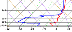
So, what can I tell you now? I’m impressed by how dry the atmosphere is.
I’m looking at a skew-t plot from this morning. Skew-t displays temperature and dew point vertically through the atmosphere. As dry as it was at ground level it was crazily dry up to around 4-5,000 feet.
Until this dry air is saturated evaporation will pull the temperature down. That’s a confirming sign we will see the powdery/fluffy snow forecast.
The most obvious confirmation of the skew-t’s data are the echoes showing overhead on the radar. My friend Bob at FSU in Tallahassee said:
The 12Z GFS model is in reasonable agreement with last night’s run. If I was forecasting now I’d probably leave my numbers intact. I guess that’s as good as it can be for me right now.
I’ll check back later as the snow flies.
Virga is death to us snow lovers. Its so dry I bet you can shave 3 inches off your forecast.