 The weekend snow seems to be coming into sharper focus. I say “seems” because I won’t know for sure until the whole thing is gone. It’s been a wild, incredibly inconsistent ride which isn’t over yet.
Last night before going on-the-air I looked closely at the 00Z¹ GFS and NAM models. The NAM called for a blizzard. The GFS had a windy day with light snow.
Before bed I took another look.
The 06Z runs were in. The NAM had gone from Armageddon to nothing! It was now showing the storm missing us! I sent a text message to Gil Simmons who was already preparing his forecast at work:
Geoff: Nam to 60h. Sorry snowman.
Gil: WTF. Gfs still had some measurable.
Gil: Nothing like flushing hrs of work
Gil: What a joke
He was right–What a joke. With all this heavyweight computing power and myriad observations this was the best we could do-vague and inconsistent guidance!
I went to bed.
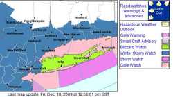
I woke up this morning and checked my phone. Craig Allen, New York’s best known broadcast meteorologist, was on Facebook. He was complaining about the Weather Service’s freshly issued “Blizzard Watch” for Long Island. It was much too early considering the inconsistency of the forecast and the immense impact on the weekend before Christmas.
By experience on-air forecasters understand it’s easier to cancel an event than un-cancel it! There’s no harm in waiting a little while longer. On the other hand there’s plenty of downside committing to a watch too early.
Before starting this entry I took a look at the 12Z GFS and NAM. Major snow is back in the NAM. The GFS has become less of an outlier and is now closer to (but still less than) the NAM solution. These models and a few more will form the basis for my forecast today.
I will spend the next few hours mulling over each detail. How much wind? When will the snow start? Will there be a burst period? What about the critical cloud temperatures which will define the snow’s fluff factor.
In the end I’ll hope to be close. There’s no bullseye in snow forecasts. You’re never exactly right. You can only hope people are well prepared and critics cut you a little slack.
¹ – To achieve global consistency all weather data is produced in “Z” time aka UTC or GMT. This time of year it’s five hours ahead of EST. So 00Z means 7:00 PM EST. That’s the initialization time. It takes a few hours for the results to trickle out.