Like Paul Blart, Mall Cop

NEsf.fronts.20140214.07

At 11:15 PM PST/2:15 AM EST

Observe and report. Like Paul Blart, Mall Cop, I’m observing and reporting.

First stop, radar. It’s active. Snow, identifiable by radar only recently, is the only precipitation being seen at the moment. It’s moving west-to-east.

Meteorologists call the radar’s targets, hydrometeors. Cool name.

We can detect rain, snow, hail, sleet, whatever. If a radar beam can bounce off it, it’s tracked.

Most times the radar is amazing. Not always. I’ve seen storms develop in an unusually bright patch of ground clutter. Surprise! Where did that come from? A once every few year event.

All my observing tonight is on the College of DuPage weather website. They carry nearly every product with well chosen color tables. Highly recommended.

The surface map shows the low pulling east, leaving New England. There’s more moisture following and colder temperatures. The snow isn’t quite finished.

Before ending this morning that additional snow will cover the slushy wet mess already on-the-ground. Up to a half foot more will fall in scattered sections of the Litchfield Hills all the way to the UCONN campus. Most areas a few inches less. Even less on the shoreline and near 395.

But still, look what it’s covering!

Oh–and windy and much colder.

The amount of forecast and observational data available is immense. New tools arrive all the time. For nerds like me, this is heaven. Forecasting in pajamas!

GPS Astounds Me

It says Mohawk Mountain is in Corner of the Pines, CT–probably a name used sometime in Connecticut’s history.

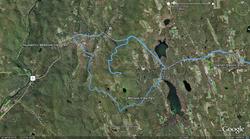
gps readout mohwak-cornwall.jpgMore than any other technology GPS and all its applications simply astound me (Click here or on the image to see a GPS track of Saturday’s photo journey to the Litchfield Hills.

Think about it. You can accurately locate yourself within a few feet instantly then get customized driving directions in seconds. I can’t imagine there is are many tasks more difficult than directions because there’s an infinite number of possible routes.

I’m using a program called GPISync right now. It’s freeware and hosted by Google. It takes the lat/lon info from a miniature GPS logger I carry when using my camera and adds that location data to each of my photos. Totally crazy!

(Found IMG_5133.CR2 …taken 2009-10-10-17:28:54, writing best latitude/longitude match to picture: N 41.821781 ,W -73.296776 : time difference (s)= 1

Geonames: 1.64 Km North-East East Cornwall Connecticut United States US, writing geonames)

The only problem is the overly complete database of placenames using many arcane or historic locators. It says Mohawk Mountain is in Corner of the Pines, CT–probably a name used sometime in Connecticut’s history.

GPS will soon be in nearly anything that moves the way clocks can now be found in nearly anything that plugs in! There are good and bad implications in that.

Waiting For The Storm

Winter is the toughest time for forecasting because viewers give you little margin for error this time of year, which is fine.

Two things can happen today. What I predicted comes true–to no one’s enjoyment, or my forecast can bust. I so wish I could root for bust, but I can’t. You have no idea what it’s like to deal with a blown winter forecast. It doesn’t happen often but it’s a painful experience.

Winter is the toughest time for forecasting because viewers give you little margin for error when slippery stuff is involved. That’s fine. After all, I do make my living claiming to be able to accurately predict the future.

Temperatures in the Litchfield Hills are already colder than I anticipated. That makes some form of frozen precipitation more likely. My call was for a significant ice storm in the hills. If temps are too warm it’s just rain. Too cold and it could be all sleet which is nowhere as troublesome as freezing rain.

Is it May yet?