In Weather A Small Change Become A Big Change With Enough Time

Tonight the models push warm air farther north and with it the rain/snow line.

They call football a game of inches. Weather too. OK maybe not inches exactly, but small errors become big errors over time. I’ve got a pretty good example of that tonight. It’s another look at Friday, but this time from tonight’s 00Z (8:00 PM EDT) GFS.

This afternoon it looked like the rain/snow line would be draped across Connecticut. Tonight the models push warm air farther north and with it the rain/snow line.

In case you’re wondering why we use these schizophrenic models the simple answer is there’s just too much math involved for a human to do much more than guess this far out.

It isn’t a big shift. 00Z was about 75 hours from the first precipitation. The change is less than a one mile per hour departure!

This is one reason to look, be prepared, but don’t go nuts Monday for Friday. The forecast will surely change again.

I’ll keep you updated.

More Winter In Your Future?

Forecasting that far out especially in the transition season is a fool’s errand.

Over the weekend a message popped up on my Facebook wall:

Big storm coming Friday. Big, big storm. Let’s see if it’s rain or snow!

I couldn’t see this Facebook friend, but it’s obvious he was salivating! Haven’t we already been through enough?

On top of that he wants to play… and this storm is demanding we play the rain/snow game. It was tough enough when I had to do it. Now I have a choice!

I answered:

Forecasting that far out especially in the transition season is a fool’s errand. There’s a chance for snow both Wednesday PM and Friday/Saturday. Beyond that, who knows?

My Facebook friend was looking for me to sign-off on his wish based prediction for snow! Wishcasting is the most dangerous thing a forecaster can do.

Some of you think that’s what TV meteorologists do. Maybe. Not me.

I went back to the computer models this afternoon. Like you I’m interested in seeing if there’s snow in the offing.

There are actually two chances. He missed the one for Wednesday afternoon into Thursday that I mentioned. We’ll be cold enough for snow, but that system now looks to be tracking south of us. Close, but no cigar.

Good!

I know. I’m supposed to be a dispassionate observer. The heck with that! I’ll be glad if it misses us as forecast. Maybe thrilled is a better word.

The later week story is much more problematic. The rain/snow line looks to cut across our state as the storm passes by through most of Friday. That sets up some very different outcomes based on location.

At this early date the Shoreline and Eastern Connecticut will see mainly rain. North and west will get mostly snow–enough to send the plows out and keep the kids home.

Here’s the operative line that bears repeating: Forecasting this early is a fool’s errand. I’ll keep my eye on it and let you know as things come into sharper focus.

It’s really too early to worry about Friday. Keep that in mind.

A Tiny Bit Of Sleet

The snow changed to sleet! Sleet is more dense and has greater survivability. We’re still a long way from accumulating here.

It’s been snowing lightly all afternoon. So far our accumulation is exactly zero. Not unexpected.

Things changed a few minutes ago. The snow changed to sleet! Sleet is more dense and has greater survivability. We’re still a long way from accumulating here. It’s very light.

This will be a small storm, but there to greet you in the morning.

I Won’t Be Disappointed By A Disappointing Snow

Just thirteen words and he got to the essence of my professional life. I don’t miss the angst, but the angst was worth it to get to the other stuff

It was 2:04 AM when an Instant Messenger window opened on my PC. My friend Bob in Florida was up. He’s a meteorologist and as nocturnal as I am. He’d been reading my blog.

I am enjoying seeing you enjoy the weather future without the stress. Bittersweet?

Just thirteen words to get to the essence of my professional life. I don’t miss the angst. The angst was worth it to get to the other stuff. That’s the bittersweet part.

I still forecast. I’m just not as worried about forecasts that go bad.

I suspect there will be some sad forecasters tomorrow, especially those who called for large amounts of snow. What’s coming looks more like a minor pain than anything else.

Helaine said the supermarket was crowded today. Someone didn’t get the memo!

Most areas of the state should get under four inches. There could be a little more in Fairfield County and parts of Litchfield. Two to four wet inches will be the norm.

The vast majority of what falls will fall overnight so you’ll wake up to it in the morning.

There are always a number of wild cards in the weather. This little storm is working against the month of March. As I type this it’s cloudy, but there’s still plenty of incoming solar radiation (insolation) warming the pavement. Temperatures won’t drop below freezing until the middle of the night. Some of what falls early on will melt on contact.

There is a certain ease I have today. That’s probably because this forecast is being done in my pajamas and not a suit!

Observations On Tomorrow’s Snow

Brad loves winter and snow as much as anyone I know. If he’s sick of it… well it’s like Lindsay Lohan complaining about the moral deterioration of America!

Oh my God! I just watched Brad Field say of the winter’s weather, “This is enough.” Brad loves winter and snow as much as anyone I know. If he’s sick of it… well it’s like Lindsay Lohan complaining about the moral deterioration of America!

Meanwhile it’s snow again for tomorrow into Thursday. Not a huge storm, but still a royal pain.

As always the computer models have agreed to disagree! The NAM is all snow while the GFS is a mixed bag on the shore with some sleet mixing in (though a smaller piece of the pie) all the way up to the Massachusetts border.

At work I’d be anguishing over this forecast. This afternoon I am calm.

I’ve included a map of the current (as I write this) Weather Service watches and warnings.

In one of those confusing situations that unbending NWS policy can produce the shading over Hartford and Middlesex Counties aren’t for this storm, but flooding on the Connecticut River. It’s flooding which isn’t really affecting anyone and is currently receding. Connecticut River flood warnings are most often (not always) for situations no one cares about!

More snow will fall than will accumulate! Some will melt on contact. Some will settle into what has fallen earlier. Whatever we get will slow things down, but won’t be a back breaker.

Spring is almost here.

Enough Already

Hasn’t Mother Nature gotten the word? Spring sprung yesterday!

I’m sitting in New Haven’s Union Station on my way to New York City. We drove here through snow!

Hasn’t Mother Nature gotten the word? Spring sprung yesterday!

If You’re Wondering How Much

As if looking out the window isn’t enough the isopleths on this map show Western Connecticut and Buffalo have comparable snowfall totals.

This morning’s Times had an excellent graphic showing the extent of this winter’s exceptional snowfall (Note: I am not using exception quite the same way it’s used in: “Billy is an exceptional student and will surely win a scholarship to Yale.”). As if looking out the window isn’t enough the isopleths&#185 on the map show Western Connecticut and Buffalo with comparable snowfall totals.

Oh the humanity!

Officially Bridgeport has 54.2″ so far while Bradley has 71.1″. Your actual mileage may vary.

&#185 – iso·pleth (ī′sō plet̸h′, -sə-) noun –The line connecting points on a graph or map that have equal or corresponding values with regard to certain variables.

There are many ‘iso’s we learned about in school: isobar, isotherm, isodrosotherm, etc. When there is no specific ‘iso’ to cover a situation (or I don’t know it) isopleth is used.

Anyone Sick Of Winter Yet?

When snow approaches people want to know as much as we know even when we don’t know all that much!

Over on Twitter the ‘house account’ for the Meriden Record-Journal newspaper just tweeted, “Reports of snow possible towards the end of the week/weekend. Anyone sick of winter yet? #ctweather”

It didn’t take long to see a reply, “I am sick of winter and you can quote me!” That was from me.

Not even two weeks into winter officially and it’s already like being on a bad blind date looking for a strategy to bail. I need a winter wingman!

We’ve only had one real snowstorm so far, but this has been the windiest winter in a long time. December was a decidedly cold month–colder than even December should be. Now there’s the chance for snow as we head into the weekend.

Here’s one thing last winter taught me: Don’t commit too far out!

It’s OK to say what looks likely, but foolhardy to make that anything more than an advisory for planning early on. If you say something will happen with certainty you will certainly be burned! I still have scars.

120 hours out an error of a mile an hour (or less) can be the difference between heavy snow and no snow! I’m not that good. No one is.

I got a note from Dr. Mel this morning. We often chat when these larger systems approach. It’s good on both sides because speaking your mind and defending your ideas is as helpful as listening!

WE HAVE NOT ONE BUT THREE DIFFEENT CIRCULATIONS TO WATCH FOR THE END OF THE WEEK…

BUT IT IS ANYONES GUESS FROM THURSDAY NIGHT ON. THE KEY WILL BE THE TROUGH LINE. AS LONG AS IT IS SOUTH OF THE AREA, A CHANNEL FOR ATLANTIC MOISTURE WILL EXIST AND WE COULD GET BANDS OF MOD.SNOW IN THOSE SPOKES.

AS USUAL ALL THE MODELS FLIP FLOP…THE 12 Z KEEPS THING POORLY ORGANIZED, AND SHIFT THE TROUGH LINE NORTHWARD…MUCH DIFFERENT FROM OO AND 06Z RUNS.

WE WILL JUST HAVE TO WAIT WATCH…I HEAR THAT A LOT LATELY

People have accused me (and I suppose all forecasters) of hyping these storms. Why? You are just as likely to watch if we claim honest uncertainty as divine insight!

When snow approaches viewers want to know as much as we know even when we don’t know all that much!

Sunday’s Driving Me Nuts

The NAM misses us entirely. The GFS brings a plowable, not back breaking, accumulation. The European model hints at Armageddon!

This Sunday storm possibility is driving me a little crazy… and by a little crazy I mean very crazy! Each succeeding run of the computer guidance just muddies the water more.

There was a time earlier this week when one model hinted at 2&#189 feet of snow! Six hours later 90% of that wasn’t coming.

Even now just a few days ahead when the models should be coming into alignment they are not. The NAM misses us entirely. The GFS brings a plowable, not back breaking, accumulation. The European model hints at Armageddon!

Who could possibly know?

Here’s the funny thing. Even a non-specific forecast is helpful. There’s something to be said about at least planning for a ‘rainy day.’

Oh, hell… rainy. I hadn’t even considered that until now.

The Giants Should Have Known

All week the forecast called for a chance of snow Saturday. By Wednesday it became “likely.

Just in case anyone asks the Minnesota snowstorm that took the New York Giants by surprise was well forecast. This is an embarrassment for the Giants and NFL and a pain-in-the-ass for everyone else.

All week the forecast called for a chance of snow Saturday. By Wednesday it became “likely.” Winter Storm Watches were issued Thursday. A Blizzard Warning was up on Friday.

At Dinner: The Snow Dispute

This is what happens when you allow San Diegans (San Diegites?) to move east where there’s actual weather. They just can’t handle it.

Here’s a little taste of tonight’s dinner. Ann, Noah and I were sitting together at the Greek Olive. We were at a window booth looking out into the parking lot.

Noah: Oh my God, it’s snowing!
Geoff: That’s flurries Noah.
Noah: No, look it’s sticking. It’s on the cars. That’s snow.
Geoff: Flurries.
Noah: No, it’s really snowing.

This is what happens when you allow San Diegans (San Diegites?) to move east where there’s actual weather. They just can’t handle it.

Basically tonight is like early October in Buffalo. Live with it.

A Storm Unlike Any Other

I called and told him I was confused because I’d never seen this particular setup before. Neither had he!

dot greenwich camera.jpg
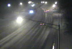
Earlier tonight I took a quick look at one of the CT DOT traffic cameras on I-95 and gasped. The camera was in Greenwich-adjacent to the New York State line. While the rest of Connecticut was seeing moderate to heavy rain with temperatures mostly in the 40&#176s Greenwich had limited visibility with heavy snow. The snow had begun to accumulate!

dot westport camera.jpg
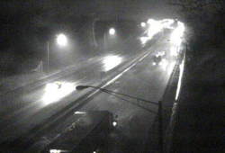
A few miles up the road in Stamford there was nothing but rain! Even now, hours later, only the communities in Lower Fairfield are seeing the snow stick.

In retrospect the Greenwich blitz doesn’t change my forecast. It was scary to see–sure. The weather had done a rapid about face. It was all part of the forecast, but it happened so quickly and with such fury I was originally taken aback.

Let me qualify this because it’s easy to lose sight of what I’m talking about.

Something’s been falling from the sky since early Tuesday. One storm came and went. This is Part B of Storm 2. However, this unnamed¹ winter storm is so unusual scholarly papers will be written about it!

Thursday while Atlantic City was seeing snow Albany, NY was getting rain. Friday morning New Haven, CT will see snow while Bangor, ME gets the rain! Crazy.

90fbw.gifThe barometer is so low it’s approaching the range usually seen in hurricanes and tropical storms. We get pressure readings this low every decade or so.
Tonight, as the wind in New London shifted from east to southwest the temperature dropped 9&#176 in one hour! Cold air advection from the southwest! Isn’t that where warm air comes from?

Seriously–that’s nuts.

I called my weather colleague Dr. Mel Goldstein this afternoon. I’d developed my forecast but was unsure about one aspect. He’s a great weather historian so I called and told him I was confused because I’d never seen this particular setup before. Neither had he!

My concern was how much warm air would remain and how much water would stay on roads as the snow fell? How would this affect Friday? My guess is a great deal of the storm will just melt as it hits the pavement–not all of it. What does accumulate will be wet and sloppy and very heavy to move.

After Friday I’ll know better how my speculation comports with the real world. I am working totally in a theoretical world right now.
I am exhausted. This week has been a killer. There’s been no forecast where I could let up because they all were jammed with critical information.

Bring on the weekend.

¹ – As long as I’ve been in Connecticut WFSB has been naming storms. It’s probably a good promotional tool for them, but on those occasions when people refer to a storm by the WFSB given name I gag. These are people who also call the Fiesta Bowl the FedEx Fiesta Bowl.