Bob, my professorial meteo friend popped an email to me a few hours ago. It was short and to the point.
 Actually, you never see that. The streamline map on the left (click on the map as the real detail isn’t visible in the thumbnail image), not always a great rain/snow predictor makes today’s line vividly clear. Of course that’s a snapshot in time. The line will shift east later tonight.
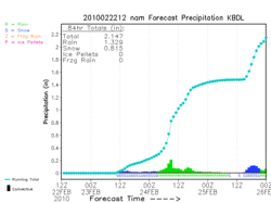
That’s where my quandary lies. I’m reasonably sure it will snow. If I scrape my mouse across one of the tools that help me analyze the computer guidance I see around 10″ of snow by tomorrow night at New Haven. There are varying amounts elsewhere, but this is just an example.
The question is, how much sticks? Does any? Does all of it?
These aren’t totally uncharted waters, but it’s certainly an unusual enough scenario that I’ll take pause. There’s too much water on the ground now to be easily absorbed–to perk beneath the surface.
Temperatures will fall below 32°, but will they fall enough to freeze the water and allow snow to fall on top? That’s a really rare setup, water-to-ice with a snow capper, which implies it’s difficult to achieve.
Snow and water don’t mix. Snow always loses. Nothing will accumulate before freezing sets in.
Is it possible to have 10″ of snow fall and have none stick? Maybe. I’m really going to have to think this through and probably chat it up with friends/colleagues to get a better grasp. I’m not sure any of us have any experience quite like this.
So, how’s your day? I don’t go to work for another hour and I’ve already been working for a few!
