The Storm’s Over — The Numbers Are In

The dry air was the wild card. Radar showed moderate snow over all of Connecticut for hours-and-hours before anything hit the ground.

snow-shovel-on-the-steps.jpgThe snow has come and gone. There’s never a bullseye, but the forecast was reasonably close. If success is judged by number of complaints, or lack thereof, I’m doing fine. Here are the final DOT numbers. I have also added the Boston and New York NWS snow totals, which include Connecticut, for the Dec 20-21, 2009 storm at the end of this entry.

Not everyone was as lucky. A friend who forecasts in Springfield sent a text message saying he’d received nothing! “Bust of the decade,” he said. Ouch. Been there. I know exactly what he’s going through.

I was right about Southeastern Connecticut getting the most snow followed by the shoreline in general. The snow was fluffy and windblown as predicted. Accumulations were generally in line with my numbers. My call for the Northwest Hills and most of the area directly adjacent to the Massachusetts line was a few inches higher than the actual totals.

I wrote about this last night, but it bears repeating the most unusual and interesting part of this storm was the exceptionally dry air. During the summer we sometimes see 30 grams of water content per square meter. Last night it was around 1 gram per cubic meter!

The dry air was the wild card. Radar showed moderate snow over all of Connecticut for hours-and-hours before anything hit the ground. Once the atmospheric column over any location became saturated light snow turned to heavy snow. I’d never seen a situation quite like this before. It cut inches off all the accumulations.

It’s a shame this storm will impact Christmas shopping. Otherwise we’re lucky it came on a Saturday night when travel is usually light.

And now the dig out begins.

(NWS totals after the jump)

Continue reading “The Storm’s Over — The Numbers Are In”

Taking The Aerial Tramway Up Mount San Jacinto

The Tramway is an 8,500 foot climb in a small, often swinging, car. The propulsion is delivered by thick cables strung over a series of isolated towers. Trust me–I’m describing Helaine’s ultimate nightmare scenario!

palm-springs-aerial-tramway.jpg“Why don’t you go?” Helaine asked. She was suggesting I ride the Palm Springs Aerial Tramway on our last day in town.

It was a tough choice because I knew she wouldn’t go. Helaine has a real fear of heights.

The Tramway is an 8,500 foot climb in a small, often swinging, car. The propulsion is delivered by thick cables strung over a series of isolated towers. Trust me–I’m describing Helaine’s ultimate nightmare scenario!

Mount San Jacinto is an amazing camera platform&#185 and, of course, that was the appeal for me. The Coachella Valley spreads out below with distant mountains marking its eastern edge.

The day was clear and mild. I threw on my jacket knowing the temperature would drop quickly with altitude. Even from the valley floor it was easy to see there was snow at the summit.

The Tramway is a short drive from Downtown Palm Springs. After turning off the main road you climb 2,500 feet before hitting the visitor center. Signs warn drivers to turn off their air conditioning lest they overtax and overheat their car!

windmills-from-mt-san-jacinto.jpgThe ride to the top was uneventful. The cable car makes two full rotations as it ascends. That assures everyone a good view.

I wish there were more open windows. Shooting through the glass is not the way to get good photos.

It was cool at the top, probably in the 40&#176s. The snow on the ground was unlike any we get here in Connecticut. It was ‘dry’ and compressed. Snow on this summit tends not to melt but sublimates away into the very dry air. There were snowy areas and clears areas, but minimal mud and no puddles!

mount-san-jacinto-nature-trail.jpgMy day at the top (December 4, 2009) was nearly dead calm. A storm moving through yesterday brought the temperature down to 14.8&#176 with wind gusts to 81 mph! I timed it right.

There’s a patio which rings the Mountain Station. From there I shot a few dozen photos of the valley below. Then I headed around back. West of the station are trails running through high mountain valleys. I picked the seemingly easy Nature Trail and began to walk.

The trail itself is easy–just 3/4 of a mile through mainly flat ground. Getting to and from the trail is a little more problematic down a long, winding, steep ramp.

tall-trees-in-long-valley-mount-san-jacinto.jpgAdded to the weight of my camera gear and steepness of the ramp is the altitude. Up on Mount San Jacinto each breath of air provides nearly 1/3 less oxygen than at sea level! This is really thin air. You feel it.

The trail itself was really pretty, but I was alone and missed Helaine. Is that too sentimental? I can’t help myself–it’s true. I know. This wasn’t the place for her. I still wish there was some way we could have shared the experience.

no-service-iphone.jpgThis was real wilderness. My cellphone showed “No Service.” That’s the 21st Century way of proving you’re removed from society.

It was a different story at the Mountain Station where I got email, answered phone calls and sent text messages.

There’s something wrong about that, isn’t there? I should have left the phone in the car, but I’m too weak. I need my tech fix.

I killed a little time hoping for some good nighttime shots with the lights of Palm Springs in view. That was a photographic failure. I never did get a really good, sharp shot after the Sun went down.

I caught the 5:00 PM trip to the bottom and was back at the hotel 10 minutes later. It was an afternoon well spent.

heading-down-mount-san-jacinto-at-dusk.jpg

&#185 – Here, as with most of the entries on this blog, clicking a photo will get you a larger version with more detail.

Hurricane Bill – Use The Power Wisely

I walk a thin line. I don’t want to panic people. I don’t want to lull them into complacency either.

hurricane-bill-visible.jpgLet me put you in my chair for just a moment.

Hurricane Bill is headed directly toward the US mainland at the moment. That’s scary. Of course forecasting weather is not just extending the current path. There are all sorts of variables taken into account. Bill should begin a sweeping right hand turn paralleling the coast over the next few days.

There is uncertainty so I look at Bill with respect and some trepidation.

I walk a thin line. I don’t want to panic people. I don’t want to lull them into complacency either.

Not only do I have to sell the most likely scenario to the public, I have to sell it to my co-workers. They are constantly on the lookout for good stories. What would cause more interest than a storm heading our way? I can’t let them ‘wishcast’.

Mission accomplished today. We handled a hurricane preparedness story in Stonington with the gravity it deserved without sending people into shock.

I have to remain diligent. We have to use the power wisely.

Speaking At West Haven High

That connection is what I hope for. It’s my sign of success.

I spoke at West Haven High School today. It was a class of meteorology students. I went as a favor to someone who’d been nice to me.

West Haven High gets a bad rap. I can’t tell you whether that’s deserved or not, but I can safely say I saw no evidence of anything remotely seeming problematic today. It is a school in a town with many working poor. The class I was in was fairly evenly divided black and white with a few Hispanics students.

I walked in fully expecting a metal detector on my way in. None. There was a non-uniformed adult on a raised kiosk watching the door and the hallway. Kids were walking around between periods as high school kids do. The vibe was nice.

The class I spoke at was a meteorology science course. I’m not sure how deep they can get in high school, but they were attentive as I delivered my presentation. That’s more than half the battle–having students pay attention. I don’t know how teachers do it day-after-day without becoming numbed to it all.

As I began I realized none of them were alive when Hurricane Gloria, a crucial first element in my talk, struck the Connecticut shoreline in 1985. Gloria is now ancient history.

I’d included my “Hippie Geoff” photo as an ice breaker. Nothing. No reaction. I was surprised and, at that moment worried about how things would progress.

As I went through my presentation I looked up to see them looking back. That connection is what I hope for. It’s my sign of success. You have no idea how many schools I’ve been to where that back-and-forth response was missing. That’s sad.

The session ended with a round of questions–some pretty good ones. I left happy.

Without sounding too sappy, I really did get a lot out of today–possibly more than the students got.

Ike Gets Scarier

Ike is especially scary now since it looks like ‘he’ will be heading into the Gulf of Mexico. It’s the watery equivalent of a box canyon with no exit but landfall.

scary-hurricne-ike.pngBob Hart’s site posts the GFDL–a computer model run optimized for and ‘bogused’ with hurricane and tropical storm data. Ive been keeping an eye on Huricane Ike.

Ike is especially scary now since it looks like ‘he’ will be heading into the Gulf of Mexico. It’s the watery equivalent of a box canyon with no exit but landfall. There are a few places with sparse population and of course that’s where you hope these storms go.

Right now, too early to be dependably accurate, the GFDL brings Hurricane Ike to nearly the same landfall that Hurricane Gustav made! I just couldn’t imagine having to deal with two strong hurricanes in the same season. I guess you do what you have to do… still it’s got to make you question where you’ve chosen to live.

We’re at the peak of the season now, give or take a few days. Hopefully the activity will begin to taper off. These storms are fascinating to forecast, watch and track, but I’m no fool, there are lives at stake.

Gustav’s Approach

Reporting from Houma, LA tonight is like being in Hiroshima to cover the end of World War II.


View Larger Map

I just came downstairs. Helaine had the Weather Channel on. I’m not usually a TWC viewer but I know who Jim Cantore is. I sat next to him at a friend’s wedding. Tonight he’s in Houma, LA. Why? In my opinion, and it is only my opinion, live TV coverage from landfalling hurricanes contributes to the “I’ll ride it out” attitude that gets people killed.

I don’t want anyone hurt, but will it take a death or serious injury before reporters are no longer stationed where hurricanes strike, just because it produces great video?

Reporting from Houma, LA tonight is like being in Hiroshima to cover the end of World War II.

Weather News I Missed

At least 55 people have died and 2.5 million have been displaced as the river changed its course. Thousands more people are being evacuated to higher ground to escape the rising floodwaters.

kosi-river-nepal.jpg

I was just scouting around the web looking for as much on Hurricane Gustav as I could find. From the official Cuban government weather site I was directed to the World Meteorological Organization’s site. Usually there’s little of interest from the WMO–a top-heavy international bureaucracy with nearly no operational responsibility.

“On 18 August, after heavy monsoon rains, a dam on the Saptakoshi (Kosi) river in Nepal burst, leaving tens of thousands of people homeless and triggering flooding in the neighbouring Indian state of Bihar, where at least 55 people have died and 2.5 million have been displaced as the river changed its course. Thousands more people are being evacuated to higher ground to escape the rising floodwaters. Roads and railway tracks have been washed away and water and electricity supplies have been affected in many areas.”

That’s staggering. 2.5 million people displaced. I can’t imagine what it must be like there.

Why haven’t I heard or read about this? Are American’s really that isolated from the rest of the world? Am I that isolated?

Charley Meet Fay

I remember Charley blossomed very quickly before landfall.

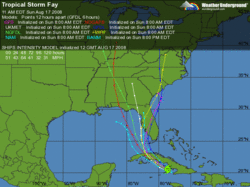
fay forecast.gifTropical Storm Fay’s track is starting to resemble Hurricane Charley’s. Charley hit Florida’s west coast four years ago this past week. Certainly, Charley took a more southerly path getting there, avoiding Hispanola and the interaction Fay is having with Cuba’s landmass. From here on out the forecast tracks are very similar.

I remember Charley blossomed very quickly just before landfall.

Charley rapidly intensified, strengthening from a 110 mph (180 km/h) hurricane with a minimum central barometric pressure of 965 mbar (hPa; 28.50 inHg) to a 145 mph (230 km/h) hurricane with a pressure of 941 mbar (hPa; 27.49 inHg) in just 6 hours. The storm continued to strengthen as it turned more to the northeast, and made landfall near the island of Cayo Costa, Florida as a 150 mph (240 km/h) Category 4 hurricane at approximately 3:45 p.m. EDT (1945 UTC) on the 13th. An hour later, the hurricane struck Punta Gorda as a 145 mph (230 km/h) storm. However, the eye had shrunk before landfall, limiting the most powerful winds to an area of 6 nautical miles (11 km) of the center.

Fay will cross Cuba a weaker storm. Cuba is quite mountainous (ask Fidel), the hurricane’s mortal enemy. However, the Gulf is very warm this time of year–explosively warm.

Our Strange Weather Day

July has been dry in Connecticut. I’ve heard many people asking for relief. I don’t think anyone wanted it this way

Wednesday was a strange weather day. Actually, since weather doesn’t necessarily follow a 24 hour cycle, this day isn’t over.

I knew something was wrong when I was awakened by thunder around 9:00 this morning. Thunderstorms in Connecticut favor the late afternoon and early evening hours. Morning storms are rare.

A bolt of lightning lives its life in an instant. So too should be the thunder. Not today. A few bolts produced a noise which undulated and rumbled for at least ten seconds. These were throaty, deep noises that rattled the house. There was no clap nor any high frequency sound. It was as if the sky was groaning.

Thunderstorms produce larger drops than stratiform rain. Today’s rain pounded down with the drops exploding as they hit a hard surface. There was nothing gentle about this storm.

By early afternoon this first batch of rain had moved away, but the air was infused with moisture. A stroll outside was like walking in a sauna. Dew points were in the 70&#176s.

Tonight storms began to reappear. While heavy rains drenched areas to our west, new cells developed overhead. I’d look at the radar and see a little patch of green. A few minutes later the area had exploded into the hot colors that correspond to downpours. The updrafts in these clouds must have been crazy–like an out-of-control elevator shooting to the roof!

A Severe Thunderstorm Watch went up between 2-3:00 PM. Though originally set to expire at 10:00 PM, it’s now on until 5:00 AM Thursday. Here, that’s unheard of.

The worst is yet to come. There will be more heavy rain–inches more. I expect flooding on Thursday in vulnerable places. It’s tough to say exactly where.

July has been dry in Connecticut. I’ve heard many people asking for relief. I don’t think anyone wanted it this way.

Fireworks At Dr. Mel’s House

Sunday night was the scheduled holiday fireworks in East Haven. For this display, a barge full of explosives is towed out into Long Island Sound. The show can be seen from any point along the length of East Haven’s shoreline. That’s where Dr. Mel Goldstein, my partner in the weather department, lives with his wife Arlene.

This is where the fireworks should be watched from. I appreciate their invitation.

They have a beautiful home–the kind you get after your children are grown and elsewhere. As far as I’m concerned, the house is in move-in condition. I like their taste.

The show began around 9:15 PM. It wasn’t perfect weather for a sky show. The state had been threatened with strong storms all day and into the night. Visibility was reduced in fog and haze. The cloud ceiling was low. The deck was wet from some earlier showers. The tide was in and directly below the railing.

I brought my tripod and an assortment of lenses. I am lost with fireworks. I really don’t know how to set the camera. Since it’s fixed and stable, I can chose as long or short a shutter speed as I please. Too many options!

I think the answer is a reasonably high f-stop, f11 as an example and around one second exposure at ISO 200. Maybe you have a better setting. I’m open to anything.

Longer shutter times bring more light and more of the frame filled. But longer exposures also make the fireworks look less sharp.

I like some of these, but I’ve seen much better. I need to learn the techniques used to get those shots.

First Named Storm – So?

I’ll answer his rhetorical question: Of course it wouldn’t have been named.

ZCZC MIATCPAT1 ALL

TTAA00 KNHC DDHHMM

BULLETIN

TROPICAL STORM ARTHUR SPECIAL ADVISORY NUMBER 1

NWS TPC/NATIONAL HURRICANE CENTER MIAMI FL AL012008

100 PM EDT SAT MAY 31 2008

…TROPICAL STORM ARTHUR…FIRST STORM OF THE 2008 ATLANTIC SEASON…QUICKLY FORMS NEAR THE COAST OF BELIZE…ALREADY MOVING INLAND.

Tropical Storm Arthur formed yesterday, and has deteriorated enough to now be ‘just’ a Tropical Depression.

It’s not all that unusual to have a named storm before the official opening of the hurricane season. I don’t draw any inference from that. However, with “A” given to a minimal storm, the season takes one quick step toward being more active than usual.

That brings up a great point made by Jeff Masters at Weather Underground.

Would Arthur have been named 30 years ago?

Arthur is one of those weak, short-lived tropical storms that may not have been recognized as a named storm thirty or more years ago. Arthur was named primarily based on measurements from a buoy that didn’t exist 30 years ago, and from measurements from the QuikSCAT satellite, which didn’t exist until 1999. There was one ship report that was used, though, and ship reports were heavily relied upon in the old days to name tropical storms.

I’ll answer his rhetorical question: Of course it wouldn’t have been named.

This is something many meteorologists point out to those who worry about an evolving atmosphere. As weather observations become more sophisticated, historical averages become that much less meaningful.

Blowing The Forecast

This entry has been edited because, it has been pointed out, most of the state was properly forecast by me… just not the city where the station sits.

I went to work Sunday night, handling the forecasting details on-the-air. A storm was brewing.

Though my call was significantly below the Weather Service and was the lowest snow prediction in the state (as usual), the forecast busted on parts of the shoreline&#185. Thankfully, my low number call was good for most of inland Connecticut.

After two hours of sleet and mixed precipitation, New Haven had six straight hours of snow at the airport… but no accumulation. The ground was too warm or too wet and the snow was already close to melting as it approached the surface.

Schools were closed. People cancelled appointments. There had been snow in the sky, but without impact.

Here’s part of an email I received:

I’ve been watching WTNH more years than I care to remember. I think the habit you have of hyping a storm coming our way is unacceptable. I’m at the point now where if I watch the weather forecast and you are the weather forecaster, I can rest assured it won’t happen. May I make a suggestion, refrain from the excitement you seem to possess, when a storm is headed our way make sure you are reasonably correct before you announce the worst scenario. With all your modern equipment you are no more correct than my father was when he went outside and looked up at the sky.

My first words at 11:00 PM were, “My wife asked me not to scare everyone,” which is what I tried to do. Of course with the Weather Service’s “HEAVY SNOW WARNING” in effect, it was tough to avoid.

Yesterday, I went on the air and apologized. I don’t know if it will make the viewers feel better. It helps me.

Bill Evans from WABC was quoted in the NY Daily News today:

“I feel like I let the public down. We didn’t get it right. At the same time, we worked as hard as we could to get it right.”

Exactly, though Bill’s bust was orders of magnitude bigger than mine.

It’s not just the forecast was wrong. It’s that it was wrong in spite of doing everything we could do to get it right. Going back, I probably would have made the same forecast. In fact, a meteorologist friend was giving me reasons to raise the numbers just before air time (I resisted).

This is the most frustrating part of what is normally a fun job. I want people to trust me. No one wants to drop the ball. No one wants to get those emails. No one wants to be quoted in an article, as Bill Evans was, titled “Now that was a flaky weather forecast

&#185 – The rest of the state’s forecast – covering 90% of the landmass and around 75% of the populace, was accurate.

Are Forecasters Liable?

Drudge has linked to an article from a Central Florida TV station that’s interesting and worrisome.

Hotel Mogul Threatens Lawsuit Over Hurricane Expert’s Gloomy Forecasts

Rosen: Fla. Lost Billions Of Dollars Because Of Incorrect Storm Outlook

I’m a non-believer in seasonal forecasts because I think, by and large, they’re awful – aka, inaccurate. By the way, the same goes for all the Global Warming hype.

Here’s what I wrote to a viewer earlier tdoay:

Viewer: I’m just wondering what the outlook is for the 2007-08 winter season. A lot of snow, not much but colder. I heard we arent’ going to get much snow. Please advise. Thanks.

Geoff: I don’t believe in them. We don’t currently have the skill. Most long range forecasts end in embarrassment for the forecaster.

Should there be a monetary downside to a bad prediction? Neither Gray nor anyone other forecaster claims divine insight and 100% accuracy. He used the best techniques known to science.

More importantly, I don’t think anyone expects 100% accuracy.

I tend to think Harris Rosen’s rhetoric is bluster and no more… but who knows? Maybe he does have a case. I’m sure there’s a lawyer willing to help him.

But why go after Dr. Gray? There are other seasonal hurricane forecasts from forecasters with deeper pockets. AccuWeather comes to mind, though there are probably others.

I’ve got a dollar that says the attorney won’t forecast the outcome nor guarantee it.

Continue reading “Are Forecasters Liable?”

Tragedy In Bangladesh

The news coming out of Bangladesh is minimal tonight. The AP reports ‘at least’ 41 people dead from Cyclone Sidr, which came ashore Thursday.

That number will surely rise after this powerful storm hit one of the world’s most susceptible points.

Around 20 years ago, I was invited to Western Connecticut State University by Dr. Mel Goldstein to listen to Dr. Bob Sheets, former director of the National Hurricane Center.

Sheets talked about the potential for tragedy in Bangladesh… the futility of knowing a storm was coming, but there was nothing to do and nowhere to go.

The Ganges River Delta, where Bangladesh meets the Bay of Bengal, is low lying land. Storm tides easily wash well inland and up the river toward Dhaka, a city of 6,500,000.

This is a country of poor people, living in mainly flimsily constructed homes and shacks. Many people live directly on the water.

Sheets said one of the things done was build earthen berms, allowing people to rise above incoming water. It was low tech and not totally effective, but it was better than nothing.

Today’s solutions seem similar:

My Beef With The Hurricane Center

Since Friday, I have traded emails with Ed Rappaport, director of the National Hurricane Center down in South Florida. He responded after I sent an email to two of his forecasters.

I was upset… No, I was livid the National Hurricane Center had decided to stop tracking and issuing bulletins and forecasts on Hurricane Noel Friday at 5:00 PM.

I’ve attached their final forecast discussion below. Two things to note. First, when they stopped their forecasting, Noel had already begun to take on non-tropical characteristics.

THE AIRCRAFT DATA ALSO INDICATED THAT NOEL STILL DISPLAYED A WARM CORE AND A FAIRLY TIGHT RADIUS OF MAXIMUM WINDS. SINCE THEN…THE INNER CORE CONVECTION HAS SUBSTANTIALLY DIMINISHED AND IS NOW INSUFFICIENT TO QUALIFY NOEL AS A TROPICAL CYCLONE. IN ADDITION…THE FSU CYCLONE PHASE SPACE DIAGRAM SUGGESTS THAT NOEL’S THERMODYNAMIC STRUCTURE IS BEGINNING TO BECOME ASYMMETRIC AND FRONTAL. THUS THIS WILL BE THE LAST NOEL ADVISORY.

Second, and much more importantly. Noel was going to get stronger!

BAROCLINIC FORCING SHOULD FURTHER INTENSIFY NOEL AS AN EXTRATROPICAL CYCLONE AS IT ACCELERATES TOWARD THE NORTH-NORTHEAST. ALL OF THE GLOBAL MODELS BOTH DEEPEN THE CYCLONE AND EXPAND THE HIGH WIND AREAS.

From a purely meteorological standpoint, NHC was correct. Noel was no longer a tropical system. They cover tropical systems – period.

That misses the point. The Hurricane Center’s job is to protect lives, not be meteorological purists.

When they stopped issuing forecasts, advisories, bulletins and maps, the job moved to the local forecast offices, like Taunton, MA and Upton, NY. Those offices have very capable forecasters (some of whom I’ve known for two decades).

Again, that’s missing the point.

By changing Hurricane Noel to an unnamed extratropical low, NHC signaled a diminished threat to the untrained public. That just wasn’t so.

There is already enough concern for public perception that the term “minimal hurricane” is no longer used in public bulletins.

Public safety officers, emergency managers and even broadcast meteorologists know exactly when and where to get data on tropical systems. It is specific and very different data than any other forecast product we get. The data from the local offices is totally different.

In the case of broadcasters, we all have equipment which automatically produces maps as the Hurricane Center’s data comes in! When that stopped, the ability to produce the most compelling and illuminating maps stopped. These maps made the case Noel meant business.

Based on the response I received from the director, I wonder if a “Hurricane of ’38” scenario would also see the Hurricane Center back off!

Something’s got to be done. That’s the bad news. The good news is, these are very bright people. I hope they find a way to change their policies before someone gets hurt.

Continue reading “My Beef With The Hurricane Center”