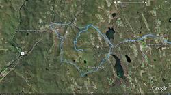
 More than any other technology GPS and all its applications simply astound me (Click here or on the image to see a GPS track of Saturday’s photo journey to the Litchfield Hills.
Think about it. You can accurately locate yourself within a few feet instantly then get customized driving directions in seconds. I can’t imagine there is are many tasks more difficult than directions because there’s an infinite number of possible routes.
I’m using a program called GPISync right now. It’s freeware and hosted by Google. It takes the lat/lon info from a miniature GPS logger I carry when using my camera and adds that location data to each of my photos. Totally crazy!
(Found IMG_5133.CR2 …taken 2009-10-10-17:28:54, writing best latitude/longitude match to picture: N 41.821781 ,W -73.296776 : time difference (s)= 1
Geonames: 1.64 Km North-East East Cornwall Connecticut United States US, writing geonames)
The only problem is the overly complete database of placenames using many arcane or historic locators. It says Mohawk Mountain is in Corner of the Pines, CT–probably a name used sometime in Connecticut’s history.
GPS will soon be in nearly anything that moves the way clocks can now be found in nearly anything that plugs in! There are good and bad implications in that.