Here Are All Of Today’s Snow Totals For Connecticut

If there’s one thing the Internet’s got it’s space! There’s plenty of room to list all the snow amounts as relayed by the Weather Service’s three offices that cover Connecticut.

If you’re looking for the 2013 snow totals, click here

If there’s one thing the Internet’s got it’s space! There’s plenty of room to list all the snow amounts as relayed by the Weather Service’s three offices that cover Connecticut.

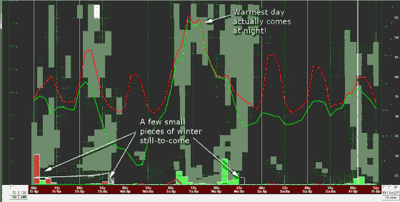
The farther south and east you were the more snow you got!

CONNECTICUT

…FAIRFIELD COUNTY…
SHELTON 9.5 215 PM 1/21 PUBLIC
MONROE 9.5 500 PM 1/21 SKYWARN SPOTTER
GREENWICH 8.0 404 PM 1/21 PUBLIC
NEWTOWN 6.9 115 PM 1/21 PUBLIC-775FT
NEW CANAAN 6.5 130 PM 1/21 SKYWARN SPOTTER
RIDGEFIELD 6.5 100 PM 1/21 PUBLIC-600FT
BRIDGEPORT 6.2 315 PM 1/21 COOP OBSERVER
STRATFORD 6.1 500 PM 1/21 PUBLIC
DARIEN 5.5 300 PM 1/21 CT DOT
NORWALK 5.5 1259 PM 1/21 PUBLIC
STAMFORD 5.0 500 PM 1/21 BROADCAST MEDIA
DANBURY 4.8 300 PM 1/21 CT DOT

…HARTFORD COUNTY…
BRISTOL 4.5 1218 PM 1/21 HAM RADIO
ROCKY HILL 4.5 411 PM 1/21 HAM RADIO
SIMSBURY 4.0 404 PM 1/21 HAM RADIO
BURLINGTON 3.5 228 PM 1/21 SPOTTER
NEWINGTON 3.3 1210 PM 1/21 HAM RADIO
GRANBY 3.0 406 PM 1/21 HAM RADIO
EAST HARTFORD 2.8 402 PM 1/21 HAM RADIO
SUFFIELD 2.5 1203 PM 1/21 HAM RADIO
MANCHESTER 2.5 1205 PM 1/21 HAM RADIO
WINDSOR LOCKS 2.4 100 PM 1/21 BRADLEY AIRPORT
WINDSOR 2.2 1226 PM 1/21 HAM RADIO
ENFIELD 2.1 1214 PM 1/21 HAM RADIO
HARTFORD 2.0 1232 PM 1/21 HAM RADIO
WETHERSFIELD 1.0 921 AM 1/21 HAM RADIO

…LITCHFIELD COUNTY…
WINSTED 3.5 318 PM 1/21 SPOTTER
NORFOLK 1.2 800 AM 1/21 CO-OP OBSERVER
BAKERSVILLE 1.0 800 AM 1/21 CO-OP OBSERVER

…MIDDLESEX COUNTY…
HADDAM 11.0 330 PM 1/21 PUBLIC
EAST HADDAM 10.5 100 PM 1/21 MEDIA
WESTBROOK 8.0 300 PM 1/21 SKYWARN SPOTTER
OLD SAYBROOK 8.0 300 PM 1/21 CT DOT
EAST HAMPTON 8.0 349 PM 1/21 PUBLIC
MIDDLETOWN 6.3 319 PM 1/21 MEDIA

…NEW HAVEN COUNTY…
NORTH HAVEN 12.0 200 PM 1/21 SKYWARN SPOTTER
CLINTONVILLE 11.9 200 PM 1/21 SKYWARN SPOTTER
HAMDEN 9.8 457 PM 1/21 SKYWARN SPOTTER
MOMAUGUIN 9.8 355 PM 1/21 SKYWARN SPOTTER
SEYMOUR 9.5 300 PM 1/21 PUBLIC
MADISON 9.2 1240 PM 1/21 SKYWARN SPOTTER
OXFORD 9.0 330 PM 1/21 PUBLIC
MERIDEN 9.0 550 PM 1/21 SKYWARN SPOTTER
WOODBRIDGE 9.0 100 PM 1/21 MEDIA
BRANFORD 8.3 155 PM 1/21 SKYWARN SPOTTER
WEST HAVEN 8.1 256 PM 1/21 PUBLIC
NEW HAVEN 8.0 300 PM 1/21 CT DOT
MILFORD 7.5 100 PM 1/21 MEDIA
WALLINGFORD 7.4 1215 PM 1/21 MEDIA – WVIT CT
ANSONIA 7.0 100 PM 1/21 PUBLIC
BEACON FALLS 6.5 300 PM 1/21 CT DOT
YALESVILLE 5.6 403 PM 1/21 SKYWARN SPOTTER
NAUGATUCK 5.0 1215 PM 1/21 MEDIA- WVIT CT
SOUTHBURY 5.0 220 PM 1/21 PUBLIC
CHESHIRE 4.5 1215 PM 1/21 SKYWARN SPOTTER
WATERBURY 4.3 300 PM 1/21 CT DOT

…NEW LONDON COUNTY…
SALEM 10.5 100 PM 1/21 MEDIA
LISBON 8.9 457 PM 1/21 SKYWARN SPOTTER
NORWICH 8.0 300 PM 1/21 CT DOT
LEDYARD CENTER 8.0 230 PM 1/21 SKYWARN SPOTTER
NORTH STONINGTON 7.4 337 PM 1/21 PUBLIC
GALES FERRY 7.3 341 PM 1/21 SKYWARN SPOTTER
GROTON 6.5 300 PM 1/21 CT DOT
COLCHESTER 6.5 300 PM 1/21 CT DOT
STONINGTON 5.7 300 PM 1/21 SKYWARN SPOTTER
MYSTIC 5.0 200 PM 1/21 SKYWARN SPOTTER

…TOLLAND COUNTY…
ROCKVILLE 4.0 405 PM 1/21 HAM RADIO
COVENTRY 3.8 417 PM 1/21 HAM RADIO
TOLLAND 3.0 1208 PM 1/21 HAM RADIO
STAFFORD SPRINGS 2.7 511 PM 1/21 SPOTTER
STAFFORDVILLE 2.3 317 PM 1/21 SPOTTER
VERNON 2.3 359 PM 1/21 HAM RADIO

…WINDHAM COUNTY…
WOODSTOCK 4.0 410 PM 1/21 SPOTTER
BROOKLYN 4.0 452 PM 1/21 HAM RADIO
EAST KILLINGLY 3.5 456 PM 1/21 SPOTTER
DANIELSON 3.2 119 PM 1/21 HAM RADIO
MOOSUP 3.0 1106 AM 1/21 HAM RADIO
ASHFORD 2.5 307 PM 1/21 HAM RADIO

A Night With My Weather Maps

Mostly we’ll see 2-4″ statewide (and by 2-4″ I mean 1-5″). In other words enough you won’t want to drive in it, but not enough to leave a lasting impression.

Here it is 1:00 in the morning, I’m not working until Sunday, but I’m sitting in the family room with my laptop watching animated forecast maps and studying charts. I am so nerdy. This is what I was meant to do.

The Saturday storm is a fast moving clipper. No one needs to go nuts. Most roads should be good-to-go by Saturday night.

I’m currently looking closely at three models: NAM, GFS and HRRR. They’re all similar in their solution. All snow.

Exact accumulations forecasts are never spot on. Mostly we’ll see 2-4″ statewide (and by 2-4″ I mean 1-5″). In other words enough you won’t want to drive in it, but not enough to leave a lasting impression.

The storm will pass south of us. The bulk of the snow should fall between 7:00 AM and 4:00 PM on the shoreline and 9:00 AM and 3:00 PM inland.

It will be cold. Some inland spots might stay in the teens though most will be in the low twenties. On the shore it will be closer to 30&#176.

Since I’ve been doing the Premier Subaru ads I’ve been promising I’d get some snow driving video. Tomorrow’s the day.

Tonight’s Stormette

The roadway was covered by a very thin and slick layer. My ‘carmometer’ read 33&#176 or 34&#176 all the way, but the ground is colder than the air.

I walked to my car tonight put on my gloves and started to brush off snow. I know this kind. I’m a snow connoisseur. It was wet, clung to surfaces and iced under tires. I’m guessing a 7:1 water:snow ratio.

Some of you are nuts! I drove home on I-91. More cars had spun into the woods than I ever remember. They must have called in extra State Troopers. Each of the accidents had one or two!

I-91 was in worse shape than I expected. On my drive from Hartford to Meriden I passed no plows or sanders. There was one on the Wilbur Cross, but he was getting off at the exit for the yard.

The roadway was covered by a very thin and slick layer. My ‘carmometer’ read 33&#176 or 34&#176 all the way, but the ground is colder than the air.

Helaine will probably get upset at me for saying this, but the snow is very pretty tonight. Looks are deceiving.

I Hate It When The Forecast Changes

Statewide it looks like that will be snow at the start. Not a lot. Not for long. Some areas could see an inch. Most won’t.

What looked like nothing on my weather maps last night looks closer to something today. This isn’t a major shot of winter weather coming, but enough to care about. My mind has switched to obsessive mode. I’m currently antisocial!

It is cold. Two lows, one over Canada the other Texas, will combine to produce a single low somewhere east of Chicago by tomorrow morning. The positioning of the resultant low is critical because it will be controlling both moisture and temperature.

The mercury will rise tonight. That’s what I’m talking about as far as temperature control is concerned. The low will be pulling in warmer air from the south.

Meanwhile moisture is also on-the-way. Statewide it looks like that will be snow at the start. Not a lot. Not for long. Some areas could see an inch. Most won’t.

As the warmer air arrives the snow goes to sleet and mixed precipitation and then rain.

Here’s the problem. The ground will stay cold longer than the air. Icy/slippery conditions are probable as whatever falls at any given moment freezes on contact. The farther north and the higher the elevation the more likely this is.

Can this be treated? Absolutely. This type of lightweight storm seems the poster child for chemical treatment! Of course that’s never 100% effective.

All of this will take place between 9:00 PM and 4:00 AM. By wake-up time the slippery part of the storm will be finished. There’s rain coming later, but nothing worrisome.

There surely will be some scattered delays. Closings probably aren’t warranted. Unfortunately, like predicting baseball rain outs there are lots of hidden factors at work. How the superintendents make up their minds is a mystery to me.

Back To Work–Back To Weather

We’re under high pressure Sunday. The air will be exceptionally dry. Sunday will be a big static electricity day!

Vacation for me the last week. A little Florida. A little Hamden. I’m back on FoxCT tonight. I have to get back into the rhythm of the atmosphere. Forecasts are made every day. You’re prepped for what you’ll see by what you have seen.

Right now I’m doing some early recon.

It’s been a crazy winter. Late October crushed snow records. Actually, it just pretty much crushed the state. After that, silence.

Of course I keep looking. There’s just little to report.

We’re under high pressure Sunday. The air will be exceptionally dry. Sunday will be a big static electricity day!

It’s possible there’ll be snow showers Monday evening. The GFS has .2″ of snow in Hartford. That’s tiny… and that’s it for the week!

There’s still plenty of time. We’re bound to get a few storms this season even if they’re clustered (as they were last year).

Of course I’ll keep looking.

Thursday’s Already Giving Me Agita And It’s Only Monday!

A few days out a small shift in trajectory spells the difference between hit and miss. You hope for the models to come into agreement… and then you just pray.

It’s December. We’re in New England. It snows. I understand. I’m still not happy about the forecast for Thursday!

When I looked at the 18Z GFS yesterday afternoon the probability for snow Thursday was fairly obvious. A low pressure system will be south of us moving east. Moisture from the low will be pressing up against cold air.

The 00Z run came in just before I went on-the-air at 11:00 PM. The snow was gone!

Of course that’s the problem. A few days out a small shift in trajectory spells the difference between hit and miss. You hope for the models to come into agreement… and then you just pray.

Snow’s back in the GFS today. It’s also showing up in the ECMWF, aka “the European.”

Typically this kind of scenario produces a light-to-moderate snow in less than twelve hours. It would be enough to close schools, but most people will be tempted to go to work.

I’m planning on rigging some cameras in my Subaru Legacy just in case Premier wants to do a “proof-of-performance” ad sometime.

Rachel and I discussed snow before she went on today. I told her I was glad not to be on the forecast at four. She said the same for tonight at 10 and 11.

There will be a lot of number crunching going on over the next few days. Pieces of the forecast will surely change.

If you absolutely, positively need something done by Thursday as of now you should probably plan to do it Wednesday!

Meteorological Winter

There’s no need to hype. You will watch if we predict flurries or a blizzard.

Yesterday, December 1, is considered the beginning of meteorological winter. Astronomical winter isn’t for another three weeks or so. It doesn’t matter. Historically, this is when the weather weather season starts.

So, here I am on a new station and some time in the next few weeks I’m going to lay out my philosophy for winter weather forecasting.

Though I hate winter that won’t temper my what I say. I don’t deal in wishcasting.

I will not consistently get the accumulation right. It’s not because I won’t try. There is only so much science has figured out. The good news is exact accumulations only matter a little.

Anything from a flurry to a few inches has the same effect. School is cancelled. Traffic slows. Mostly people get by.

Two to about eight inches most people work, but many appointments and optional trips are cancelled. No one’s travelling that really doesn’t have to.

Above eight inches the state stops. Essential services continue slowly. Weatherman driving Premier Subaru’s&#185 find a way to get to work but most people don’t bother. Lt. Paul Vance appears on all television stations.

There’s no need to hype. You will watch if we predict flurries or a blizzard.

We’re pretty good on storm timing and whether it actually will snow. I can’t remember the last time snow was a surprise. Long time.

I use “we” because most meteorologists come to similar conclusions with the daily forecast. That’s why the most important criteria in where you get the forecast is who does the best job explaining. Do you actually understand the incoming storm? That’s much more than numbers.

I hope I’m that person for you. You should listen to whomever you’re comfortable with.

There is more pressure on the weather staff when snow is in the forecast. Tensions are high.

Rachel Frank told me she’s tightly wound when storms come. Me too. Someone pack the Maalox.

Missing a winter storm forecast upsets me greatly. They are my lowest moments.

&#185 – I am the spokesman for Premier Subaru, do their commercials and happily drive the car.

It’s April For Heaven’s Sake

It’s not winter but also not summer. It has parts of each and they’re fighting like some sort of global hormonal imbalance.

Spring is the climatic equivalent of being a teenager!

Remember your teen years? Not a kid. Not an adult. Spring is similar. It’s not winter but also not summer. It has parts of each and they’re fighting like some sort of global hormonal imbalance.

We saw low 50s today. It still doesn’t feel like spring! Here’s the 4:00 PM observation from Bradley:

KBDL 021951Z 29012G24KT 260V320 10SM FEW060 BKN080 BKN200 11/M03 A2944 RMK AO2 PK WND 28027/1935 RAB09E20 SLP969 VCSH SE AND W-NW P0000 T01061028

Buried in that mess of digits is “RAB09E20.” It’s saying rain began at 3:09 PM and ended at 3:20. Just a trace fell. It was enough to make the low fifties underachieve.

Spring is a season of unstable airmasses. That’s especially true when it’s mild at groundlevel and cold up in the clouds. Parcels of air rising from the heat of the day become very buoyant which can lead to storminess.

The radar had that unstable look today. There were dozens… maybe hundreds of tiny individual showers between the Great Lakes and New England.

Tomorrow a stronger area of instability will move to the eastern edge of the Great Plains. There’s a chance of severe thunderstorms or even tornadoes from Lake Erie to the Rio Grande!

That system’s here Monday bringing rain and temperatures which will eerily continue rising long after the Sun’s gone down. The thunderstorms probably won’t make it this far east.

The rest of the week is up and down–not quite spring, not quite winter, though still the chance of a smidge of wintry weather. Not a lot. Not on the shoreline. Still, we’re in April for heaven’s sake.

No Spring In This Forecast

What’s happened has happened. What about the future?

Don’t ask!

It’s baseball season. It must be spring, right? Who am I kidding? This is spring like we’re out of the recession! A statistical case can be made, but no one believes either is happening any time soon.

Here are some snow totals from our overnight storm:

LITCHFIELD COUNTY...
NORFOLK 2.6 800 AM 4/01 CO-OP OBSERVER
BAKERSVILLE 2.5 700 AM 4/01 CO-OP OBSERVER
COLEBROOK LAKE 2.0 700 AM 4/01 CO-OP OBSERVER
THOMASTON DAM 1.5 700 AM 4/01 CO-OP OBSERVER

HARTFORD COUNTY...
COLLINSVILLE 1.8 744 AM 4/01 HAM RADIO
1 WNW WINDSOR LOCKS 1.3 700 AM 4/01 BRADLEY AIRPORT
ROCKY HILL 1.0 638 AM 4/01 HAM RADIO

...TOLLAND COUNTY...
TOLLAND 2.3 926 AM 4/01 SPOTTER
COVENTRY 1.5 731 AM 4/01 GENERAL PUBLIC
STAFFORDVILLE 1.0 500 AM 4/01 COOP

...WINDHAM COUNTY...
UNION 2.6 441 AM 4/01 HAM RADIO
EAST KILLINGLY 1.9 708 AM 4/01 SPOTTER
HAMPTON 1.5 700 AM 4/01 COOP

That’s water under the bridge. What’s happened has happened. What about the future?

Don’t ask!

The BUFKIT&#185 graph attached to the entry shows conditions at Bradley Airport over the next week as seen by the GFS model.

Gruesome!

There is only one day forecast above 50&#176! Worse, that ‘warmth’ comes overnight–a sign it’s being advected in as a storm approaches. It’s a strong enough storm that I wouldn’t write off the chance of thunderstorms Tuesday afternoon.

There are no major winter events predicted, but three of the days have a chance for a little sleet or snow. A little sure, but it’s April for heaven’s sake!

My forecast: Spring will continue to suck.

&#185 – BUFKIT displays the timeline right-to-left. The current day is on the right. Next Friday is on the left.

Not A Lot Of Surprises In This Storm

“I wore a short sleeve shirt and flip flops to work,” she said.

Children have been written out of wills for less! Don’t test me.

I spent the evening in the mancave with my friend Rick. No coat. I’m mancave ready… even outside!

I called Stef in Southern California as I made my way home. Big mistake! It was cold and mainly rain at Rick’s. That was as far as you could get from her weather.

“I wore a short sleeve shirt and flip flops to work,” she said.

Children have been written out of wills for less! Don’t test me child.

This afternoon the weather station on the USC Campus near Downtown Los Angeles read 91&#176 with a dew point of 50&#176.

Our 3:00 AM readings have just arrived:

CITY SKY/WX TMP DP RH WIND PRES REMARKS
BRADLEY INTL LGT SNOW 33 31 92 N12 29.60F FOG WCI 24
HARTFORD LGT SNOW 35 32 88 N12 29.58F FOG WCI 27
DANBURY LGT RAIN 34 32 92 NE6 29.57F WCI 29
WTRBRY/OXFORD CLOUDY 32 28 86 NE15G21 29.56F WCI 22
BRIDGEPORT RAIN 36 32 85 NE12 29.56F WCI 28
MERIDEN LGT RAIN 34 31 88 N8 29.55F WCI 27
NEW HAVEN LGT RAIN 36 33 89 N13 29.54F WCI 27
CHESTER NOT AVBL
GROTON LGT RAIN 36 32 85 NE13 29.52F WCI 27
WILLIMANTIC LGT RAIN 34 32 92 NE7 29.58F WCI 28

A few quick notes. Waterbury/Oxford’s weather sensors haven’t worked for the last few years. Cloudy doesn’t mean there’s no precipitation at OXC (the airport’s identifier).

Chester’s weather site (SNC) hasn’t been dependable for months. For a while it was reporting a higher dew point than temperature. That’s a physical impossibility.

I walked downstairs and opened the door a half hour ago. It looked like rain, but sounded like sleet was mixed in. I decided listening was observation enough.

It’s a little tough to see what’s going on via the DOT traffic cameras. They’re not well lit! This shot from West Hartford looks to have some icy slush on the shoulder. There’s probably a little, not much, on the road surface too.

At this hour radar shows more precipitation to come. My earlier call on who gets rain, slush or snow stands.

Though temperatures on the ground will remain fairly steady the prediction at cloud level is for falling temps. That means more snow than rain in those areas already seeing snow. Of course the ground is wet. It will take a lot of snow to overcome the puddles and cover the roads.

I’m sticking to my guns on Litchfield County and far Northern Connecticut being the only places where there will be a real weather impact over the next few hours.

One more note before I go. Be careful with the radar during the winter! If there’s sleet falling through the clouds the returns will look stronger than they should. Sleet is very reflective to radar beams. You have to develop an eye to see it, but there is some “bright banding” in evidence tonight.

It would be nice if this was the end of winter, wouldn’t it?

A Quick Forecast Update

For most locations this storm will be a minor inconvenience.

As of this afternoon there is a new model to look at. The storm has moved into the realm of the RUC (Rapid Update Cycle). That’s a short term mdel run every hour. It is in agreement with the NAM and GFS which both seem a little warmer than last night.

What this means is a shift of the rain/snow line a little farther north. Not much, but at this stage of the game even 10 miles is a big deal. A combination of rain and snow usually means we only deal with the rain.

For most locations this storm will be a minor inconvenience. Accumulations should be slushy if there’s any snow to accumulate at all. I won’t be surprise to see Hartford, Middletown, and Storrs with no need for plows. On the shoreline you’re off-the-hook.

It’s still cold and wet enough for significant snow in the hills and some other areas close to the Massachusetts border. I’ll be looking for pretty pictures from friends in Warren and Kent.

I’m Ready To Commit

The best way to look at it is by drawing a diagonal between Union in the north and Greenwich in the southwest.

This is such a guy thing. We just don’t want to commit! Oh, what the heck. I will anyway. I think I have a reasonable handle on the storm which will be over Connecticut Thursday into Friday.

I posted a little note on Facebook and Twitter Wednesday evening.

I want to have more time to digest it and the GFS, but it seems the 00z NAM is a little warmer. The NAM had been the snowier model

The little animation at the top of this entry doesn’t show perfect alignment between the GFS and NAM, but they’re now pretty close! By allowing the low pressure center to move farther north the NAM is hinting at more rain, less snow.

This is Connecticut. We don’t get weather, we get samples! That will be true with this system. Everyone will get a little of everything, but the farther south and east you are the larger percentage of what you get will be rain.

The best way to look at it is by drawing a diagonal between Union in the north and Greenwich in the southwest. South of that line will be mostly rain. North of the line will be mostly snow.

Of course it’s not that simple!

Rain is the mortal enemy of snow! Rain on the ground will usually ‘eat’ snow as it falls. That’s why I’ve divided the map at the bottom of this entry into three parts&#185.

Hartford, Waterbury, Danbury, Colchester, Middletown and Storrs will get a few wet and slushy inches. If you only look at the snow falling by your window you’ll think there should be more on the ground! Most of that central slice of the state will see light snow, then rain, sleet or a wintry mix, then back to snow late Thursday night.

Closer to the shore there probably won’t be any accumulation at all. It’s still going to be a stinker of a day–cold and wet!

In the higher elevations of the Northwest Hills I wouldn’t be surprised to see some foot plus accumulations. Most areas will get significantly less.

It will be sloppy at wakeup Friday morning. Some areas will see delays or closings. Most places will not.

On a night like this I might have gotten as much as three minutes to deliver the weather on TV. I think you’re getting more meat here.

&#185 – It’s times like these when I miss the computers we used to display the weather on television.

Nearly all our software came from Weather Central in Madison, WI. If there’s a way to do their graphical magic from home I haven’t figured it out… and I’m pretty resourceful where this stuff is concerned.

I have a new found respect for something I often took for granted.

One Storm Two Forecasts

Now the good news: Uhhhh…. gimme a minute here. There must be good news.

There’s a difference between forecasting on the sofa and on the TV. I feel much more relaxed on the sofa. As some commenters have noted it might be because I have more time and latitude to explain why I’m saying what I’m saying. This upcoming system needs a lot of explaining!

First the bad news: The two main forecast models still disagree with one another. There’s still no way to make a definitive rain/snow call.

Now the good news: Uhhhh…. gimme a minute here. There must be good news.

I guess the good news is this system is smaller if it’s snow than if it’s rain! In other words a nasty, rainy day or a day of light snow (except the Northwest Hills where everyone else’s big rain might be your big snow).

I’ve attached a model comparison chart for New Haven&#185. The newest projections are on top. The reason the precipitation flutters from green (rain) to blue (snow) is because we’re going back and forth from GFS to NAM to GFS to NAM, etc.

The NAM, our snow monger, keeps it’s low pressure center a little farther south and keeps more cold air in place. The GFS pushes some of the cold air out of the way as it tracks farther north.

The NAM is a also faster, but both models start the precipitation around midday Thursday. Both systems start as snow though the GFS gradually turns that snow to rain in all but the highest elevations.

In most cases I choose the GFS over the NAM, but this is too perplexing to declare a favorite.

Neither model calls for much accumulation before the Sun sets. It’s possible some schools might dismiss early, but I wouldn’t blow off studying for a 7th period test (and I am an expert at blowing off 7th period tests).

No matter whether it’s rain or snow Thursday will qualify as nasty–a cold and damp day.

&#185 – Thanks to North Branford and Florida State University’s Dr. Bob Hart and CoolWx.com for tonight’s graphic. Bob has an amazing ability to turn abstract numbers into visualizations like this chart.

Mother Nature’s Still Deciding

The GFS is forecasting a heavy rain event for nearly all of Connecticut. The NAM is much snowier with rain mixing in close to the shoreline.

You humored me yesterday by staring at the weather map I posted. I’ll press my luck again this time with four maps! This is a comparison of two different models, the NAM and the GFS, and how they depict rain versus snow.

These are the most commonly used weather models. They’re in agreement right now about as much as the Republicans and Democrats are!

Here’s the setup. Everything you see on the left map is rain. Everything on the right map is snow. An arrow on each map points to Connecticut.

Look closely and you’ll see the GFS favoring the left map over Connecticut. The NAM favors the right.

The exact numbers aren’t all that important now because I can guarantee they’re not accurate! Look instead at the colors. The hotter they are the more precipitation is predicted.

The GFS is forecasting a heavy rain event for nearly all of Connecticut. The NAM is much snowier with rain mixing in close to the shoreline.

Where they both agree is in accelerating the precipitation. It now looks like we’ll see the first of it (whatever it is) sometime Thursday afternoon. The NAM has everything ending around rush hour Friday. The GFS is a little slower and holds the rain into Friday afternoon.

Do you see why this stuff frustrates me so? Sure, we don’t miss them like ’78, but there’s still a lot of hemming and hawing on my part when I’d rather be firm.

Since we’re so much closer to the even my method of forecasting will change a little. I’ll start paying closer attention to how the models were initialized. That means I’ll check to see if that data fed into the computers as they started their work matches the real world conditions. Because of the methods used to create the initial conditions they don’t always!

I’ll keep you up-to-date.

It’s nice to be in the saddle again.

Friday’s Storm: Less Stable Than Charlie Sheen!

Because this storm has much colder air on its west side moving the center farther east chills the atmosphere above us! That’s why the chance for snow is now greater.

This entry was originally labeled Saturday’s storm even though the content made it clear it was Friday’s! I have fixed the title. Not my day.

At this point the storm due for early Friday is showing less stability than Charlie Sheen! What looked like snow early Monday and rain late Monday has reverted to its evil ways. The guidance points to snow again… and its arrival now as early as Thursday night! I won’t be surprised if the scenario changes again.

In order to better explain what meteorologists look at I’ve created a small animated map (above). These things are always confusing to people who don’t deal with them on a daily basis so let me lay out what you’re seeing.

First, there is a map under there! It’s hidden because it’s overlayed with indicators for precipitation, sea level pressure and atmospheric thickness. To make it easier I’ve thrown in an arrow pointing to Connecticut (its tip is pretty close to New Haven).

Second, the two maps in the animation both correspond to a forecast for 2:00 PM Friday, One was produced last night, the other this morning.

Third, the center of the storm is the center of the circular lines and marked by the letter “L.” The center of the storm is where the barometric pressure is lowest.

OK? I haven’t lost you yet, right?

What’s the difference between the maps? Last night the center of the low was over Northcentral New Jersey. Today it’s pushed just east of Cape Cod.

Because this storm has much colder air on its west side moving the center farther east chills the atmosphere above us! That’s why the chance for snow is now greater.

I still expect rain to mix in on the shoreline and much of this snow to be heavy and wet. If (and that’s the operative word)… if this forecast holds much of Connecticut will see six inches of snow or more.

As we move forward the models should begin to stabilize. We’ll also start having access to more models that don’t even attempt to forecast this far in the future.

Is there utility in a forecast this likely to change? Yes! Knowing there’s a reasonable chance for a storm allows people to have alternate plans. On the other hand it’s much too early to cancel or change your plans.

These were the work days I hated. I don’t want to disappoint.

I wish there was a way to be absolutely sure and know the forecast would never change. Dream on.